


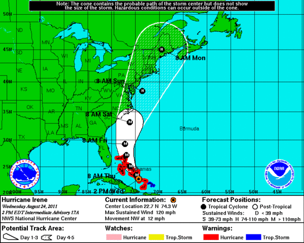
A NOAA and National Weather Service map showing a projected path of Hurricane Irene as of 2 p.m. Wednesday

August 24. COURTESY OF NATIONALWEATHER SERVICE

In preparation for the storm area residents were already stocking up on supplies at Herrick Hardware in Southampton on Thursday. DANA SHAW

Bottled water was flying off the shelves at Waldbaum’s In Southampton on Thursday. DANA SHAW

Bottled water was flying off the shelves at Waldbaum’s In Southampton on Thursday. DANA SHAW
UPDATE:
7:58 a.m., Sunday, August 28
Southampton Town Supervisor Anna Throne-Holst said early Sunday morning that there were many trees down, causing power outages. Dune Road was completely flooded and impassable. So far, one structure fire, in Flanders, was reported. The Quogue Firehouse was without power and unreachable, with a failed generator. She said the worst has not hit, as waters were rising with the tide and coastal surges were expected in next few hours.
***
UPDATE:
7:47 a.m., Sunday, August 28
According to Southampton Town Police Lieutenant Robert Iberger of the town’s emergency management office, the Long Island Power Authority is reporting 256,000 outages in Suffolk County and 4,353 in Southampton Town so far, with 229 in Bridgehampton, 1,952 in East Quogue, 987 in Southampton and 1,150 in Water Mill, with less than five reported in a number of other communities.. Downed trees are increasing, so loss of power will likely increase.
In East Hampton, LIPA is reporting 2,298 outages, with the majority, 1,966 in Amagansett. There were 269 outages reported in East Hampton, none in Montauk, none in Northwest Harbor, none in Springs and 63 in Wainscott.
***
UPDATE:
7:41 a.m., Sunday, August 28
According to Kyle Struckmann, meteorologist for the National Weather Service, as of 5 a.m. Hurricane Irene was located 15 miles south-southwest of Atlantic City with maximum wind speeds of 75 mph. It has picked up speed, he said.
It is expected to make landfall near the Queens-Nassau border a little later than predicted, now at about 10 a.m. And it is now expected to be a borderline storm, somewhere between a Category 1 hurricane and a tropical storm. With winds of 75 mph, it is on the low end of the threshold and could be a tropical storm with winds of 39 to 74 mph. The storm has maintained its track and is right along the Jersey Shore. Mr. Struckmann advised residents to stay inside and “just hang tight.”
***
UPDATE: 11:56 p.m., Saturday, August 27
Hurricane Irene is raging north, picking up speed as it prepares to pummel the East End of Long Island when it slams onto the scene as a Category 1 storm with damaging 80 mph winds and drenching rains.
And to add another level of drama to Mother Nature’s wrathful display, a tornado watch was issued by the National Weather service for Long Island earlier this evening.
Hurricanes making landfall sometimes spark tornadoes.
According to the National Weather Service’s latest report, issued at 11 p.m., Hurricane Irene, located about 70 miles south-southwest off the coast of Ocean City, Maryland and 255 miles south/southwest of New York City, is saturating the mid-Atlantic states with fierce rain.
Moving north/northeast at 16 mph, the hurricane “did speed up a little bit,” said Ashley Sears, meteorologist for the National Weather Service.
Experts still expect the storm, which has had no shift in track since the last report earlier Saturday night, to make landfall on the Queens/Nassau County border at approximately 8 a.m.
The storm is slated to be a “low end Category 1 hurricane,” with sustained wind speeds of 65 to 75 miles an hour and higher gusts.
Residents waking up on the East End tomorrow morning will see a soggy mess. “They’re going to be seeing rain,” Ms. Sears said, 6 to 12 inches, with locally higher amounts. The heaviest rainfall is expected east of the storm in New Jersey and Pennsylvania, with areas west of the eye of the storm, including the East End, expected to be whipped by high winds.
The storm surge is expected to be between 8 and 8 feet, with high tide expected at 8 a.m. on the East End.
***
UPDATE:
6:47 p.m., Saturday, August 27
The countdown to Hurricane Irene’s arrival on Long Island is on—and experts say with night falling, all that’s left to do is take cover and wait.
“Not only do you have deteriorating conditions, but you also have nightfall,” said Tim Morrin, observation program leader for the National Weather Service in Upton, New York. “Ideally, all the preparations have taken place because as it continues to get darker, preparations will need to be rushed to completion.”
Currently, Hurricane Irene is a Category 1 hurricane, located 50 miles south/southeast of Norfolk, Virginia and 340 miles south/southwest of New York City. Winds are down a bit from 2 p.m., at 80 miles per hour—they lessened slightly due to “land drag,” Mr. Morrin said.
The storm is moving north-northeast at 13 mph, and despite slightly lower wind speeds, Hurricane Irene has not weakened and is expected to slam into Long Island tomorrow morning as a Category 1 hurricane, with winds of at least 74 mph and a possible deluge of up to 12 inches of rain.
The storm track will move north/northeast along the coast of New Jersey overnight, with the East End seeing tropical force sustained winds of 40 miles per hour or more around midnight. As the night progresses, the winds will slowly pick up as rain bands increase in intensity.
Landfall, between 9 and 10 a.m, will be on the Nassau County-Queens border, bringing fierce hurricane force winds and gusts by 10 a.m.
When all is said and done, Hurricane Irene will blast north tomorrow afternoon, with area winds subsiding to under 40 miles per hour by 7 p.m. Sunday.
The East End is seeing the far outer bands of the hurricane. The bands extend hundreds of miles from the storm; winds are approximately 15 mph. “For the short term, it’s going to get wet,” Mr. Morrin said. “What you see is what you get—until about 9 p.m.” No dramatic changes of any kind are expected until then, so it might be a good time to get last-minute things done.
Rain will intensify. Winds will pick up to 30 mph.
Tropical storm force winds of at least 40 mph will begin to pummel the East End, bringing down branches and trees, if the soil is saturated and root systems compromised.
Winds will increase slowly up to 55 mph.
Weather conditions intensify, with 55 mph winds and rain bands more severe. Possible thunder and lightning; intense rain squalls and heavier wind gusts.
“It gets worse,” said Mr. Morin. Hurricane force winds will blast the East End, beginning at 75 mph. Conditions will continue through noon, with up to 12 inches of rain. The heaviest rains, however, are expected to fall west of the storm track, in New Jersey and the lower Hudson Valley. The East End, on the east side of the storm, will see heavier winds.
Winds subside, and the cleanup begins.
***
UPDATE:
6:03 p.m., Saturday, August 27
Hurricane Irene is Westhampton resident Casey Sheren’s first real up close and personal encounter with Mother Nature.
Ms. Sheren, 18, a student at Tufts University who lives on Tanner’s Neck Lane in Westhampton, said an emergency responder from the Eastport Fire Deparment stopped by her family’s home, located about a quarter mile from Moriches Bay, to order mandatory evacuation on Saturday. Her parents, Scott and Robyn Sheren, had planned to voluntarily evacuate, anyway, she said.
But with all hotels in Riverhead booked solid, Ms. Sheren’s parents headed to her aunt’s home in East Northport—and Ms. Sheren opted to seek haven at the East Quogue home of her boyfriend, Robert Tureski, and his family.
“The hurricane is a little unsettling,” Ms. Sheren said, adding that she wasn’t nervous about having to evacuate, since her family had been anticipating having to pack up anyway.
Her first-ever hurricane warranted snacks—Ms. Sheren said she baked peanut butter and chocolate chip cookies for the storm and stocked up on movies to watch. And she brought along the one thing she couldn’t leave behind: her dog, Rumi. “I’ve never experienced a hurricane,” she said. “I’m pretty excited.”
Remsenburg resident Scott Christ, 56, who lives on Cricket Path, with a home close to Moriches Bay, was told a mandatory order to evacuate was in effect at about 1:30 this afternoon. But Mr. Christ opted to stay home and weather the storm in the home he built himself in 1999.
Mr. Christ, at home with his daughter, Julia, a student at Providence College in Rhode Island, said his wife, Dawn, and son, Alec, were in Buffalo getting Alec settled in college, where it was “nice and sunny.”
Mr. Christ said he opted to stay home rather than evacuate because he believes the dangers are not as dire as predicted. “I don’t think much of anything is going to happen, and if it does, there is still a lot of time left to do something about it,” he said. “There really is not a very good alternative. I think I will be just as safe, and more comfortable, at home.”
Besides, he said, his home is built at 10 feet above mean high tide, a safe elevation.
With an eye toward safety, Mr. Christ brought lawn furniture inside, put cars on the front lawn at a higher elevation of property, and tied extra ropes on his boat. But he believes his home is safe for the duration. “I think this is going to be nothing. They are saying gust of 85 mph—I’ve had 90-mph winds since I built this house, and they did nothing.”
***
UPDATE:
5:36 p.m., Saturday, August 27
Officials expressed concerns on Saturday about how badly Hurricane Irene would batter East Hampton Town beaches.
At a storm preparation meeting at East Hampton Town Hall that morning, Diane McNally, clerk of the Town Trustees, said she and her fellow officials were expecting to see erosion.
“The Trustees are holding our breath and waiting to see what happens afterward,” she said. “That’s when our true abilities are going to be tested. We know there is going to be damage.””
Supervisor Bill Wilkinson said the State Department of Environmental Conservation was prepared to quickly issue emergency permits for shoreline repairs, so resort and hotel owners might be able to squeeze a few more business days out of the high season.
Ms. McNally said she has received calls from homeowners on Georgica Pond who were concerned about flooding. Ms. McNally said the Trustees would not open up the barrier between the pond and the ocean to lower the water level, but added that the storm may do that on its own.
“It doesn’t seem correct to open that pond in the face of a storm surge,” she said. “It’s not going to do anybody in there any benefit. It’s not going to surprise me if Mother Nature is going to do that herself during the storm.””
Mr. Wilkinson said storm surges and shoreline damage were anticipated on both southern and northern shores.
Authorities closed beaches in East Hampton Town on Saturday.
***
UPDATE:
4:32 p.m., Saturday, August 27
The East Quogue Fire Department confirms that its crews are now evacuating all residents located on any body of water—including creeks and bays.
***
UPDATE:
3:29 p.m., Saturday, August 27
As skies darken and the first rain falls, East End residents are scrambling to stock up on last-minute supplies, while others living in low-lying areas seek safe haven subject to mandatory evacuation.
Experts say that Hurricane Irene shows no signs of subsiding before she slams onto Long Island tomorrow morning, making landfall at around 9 a.m.
According to reports by the National Weather service, Hurricane Irene is still a Category I hurricane, meaning sustained wind speaks of at least 74 mph are expected.
Hurricane Irene is expected to remain a Category 1, with maximum sustained wind speeds of about 85 mph, with higher gusts, when it batters the shoreline and makes landfall in western Long Island, according to an official status rendered by the National Hurricane Center in Florida.
And, as Hurricane Irene charges forward, experts at the National Weather Service office in Upton, New York, say the guesswork is gone from scenario.
A few days ago, when Hurricane Irene was farther south, meteorologists discussed a variety of models and trending that could occur.
“That’s normal for three to four days out,” said Tim Morrin, observation program leader with the NWS. “That’s all over with now. Now, we can see the whites of the eyes of the storm. There’s much more confidence.”
And when all is said and done, Hurricane Irene is expected to make landfall much farther west, on the Queens/Nassau County border, than initially suggested a few days ago.
As of 2 p.m. Hurricane Irene, located about 45 miles north-northwest of Cape Hatteras, North Carolina was steam rolling north with maximum sustained winds of 85 miles per hour.
Hurricane warnings are still in effect for all of Long Island.
During the next 24 hours, Hurricane Irene, if it stays on track, is expected to move north/northeast at a slightly faster speed.
The center of the massive storm is expect to move across northeastern North Carolina this afternoon, then to head near or over the mid-Atlantic coast tonight, and then, move toward southern New England on Sunday.
Currently, sustained winds remain at 85, with stronger gusts. The forecasts a slight weakening as Irene eastern North Carolina, but experts warn residents not to let their guard down—the storm is forecast to remain at or near hurricane strength as it moves onto Long Island.
Gale force winds of up to 50 mph are expected as the storm approaches Long Island at 8 a.m, quickly followed by hurricane force winds of at least 74 miles per hour at 9 or 10 a.m.
Although Hurricane Irene slowed a bit over land in North Carolina, “it never stalled or stopped,” said Mr. Morrin. Currently located over the eastern portion of the Outer Banks in North Carolina, the area is a low lying area where the storm will not run into a lot of friction or mountainous areas.
Next, the storm is expected to move away from North Carolina and back out to the Atlantic Ocean later this evening, which will help Hurricane Irene to maintain its strength and life cycle up through Long Island, Mr. Morrin said—hitting the area with hurricane force winds.
Hurricane force winds extend outward up to 90 miles from the center, and tropical storm force winds extend outward up to 260 miles—o the East End will experience tremendous storm surges, intense winds, heavy rainfall of between 6 to 12 inches, with isolated maximum amounts of up to 18 inches in some places, and extensive flooding.
A wind gust of 78 mph was recently measured at Cape Hatteras in North Carolina and a wind gust of 67 miles per hour was reported at Langley Air Force Base in southeastern Virginia.
The extremely dangerous storm surge will raise water levels by as much as four to eight feet above ground level in the hurricane warning area, including the East End. The surge will be accompanied by large, destructive, and life-threatening waves, according to the National Weather Service. Higher than normal astronomical tides also occur this weekend, and extensive coastal flooding is expected.
Large swells generated by Irene can also cause treacherous rip current conditions.
Significant uprooting of trees could be sparked by rain-softened grounds.
***
UPDATE:
3:29 p.m., Saturday, August 27
Sag Harbor Village Mayor Brian Gilbride at 1 p.m. declared a state of emergency for the village.
An evacuation shelter at Pierson High School at 200 Jermain Avenue will open at 8 p.m. Residents seeking shelter have been advised to bring bedding, prescription medicine, nonperishable food and bottled water.
Residents in low-lying areas, coastal areas or areas previously known to have flooding are asked to evacuate under a voluntary evacuation.
***
UPDATE:
3:19 p.m., Saturday, August 27
East Hampton Town Supervisor Bill Wilkinson issued a state of emergency at about 9:30 a.m. Saturday, in preparation for Hurricane Irene.
The state of emergency allows police to close roads and remove parked or stranded vehicles that pose hazards, officials said.
At a public meeting at 10 a.m. Saturday morning, Mr. Wilkinson said two shelters would be open in East Hampton Town, one at East Hampton High School on Long Lane and another at the Montauk Playhouse Community Center on Flamingo Road.
The Red Cross is staffing the East Hampton shelter and, because the organization is short-handed, the Ladies Auxiliary of the Montauk Fire Department is staffing the Montauk shelter, where pets are allowed. Pets brought to the East Hampton shelter will be transported to the Animal Rescue Fund of the Hamptons in Wainscott, Mr. Wilkinson said.
Once people enter one of the shelters, they will not be able to leave until released by a shelter manager, officials said.
All beaches were roped off by police on Saturday morning, and police, marine patrol and lifeguards will be patrolling the shore to kick lingering thrill-seekers off the beaches, officials said.
“I cannot trust Mother Nature to be gentle with people simply because they’re visitors to our special spot out here,” Mr. Wilkinson said.
Mr. Wilkinson praised town staff for their hurricane preparations, saying officials started meeting on Monday to lay emergency plans.
On Friday, the town advised a voluntary evacuation of the entire town, suggesting that if residents chose to leave they should do so as early as possible. Mr. Wilkinson said he has chosen not to order a mandatory evacuation because he was told officials were not allowed to take “punitive action” to force people out of their homes.
“A mandatory evacuation is something that creates, I guess, a greater sense of urgency at best. We have instead, probably a day earlier than a lot, went out with a voluntary evacuation,” he said.”
A “reverse 911” call went out to low-lying areas on Friday advising residents of the dangers of storm surges and flooding, officials said. Fire department members were going door-to-door Saturday in those areas to issue further warnings, Mr. Wilkinson said.
The Long Island Power Authority has parked vehicles at East Hampton Airport in preparation for the repairs in the aftermath of the storm, and was prepared to send as many as 2,000 employees to the town starting Monday, Mr. Wilkinson said.
The power grid in Montauk is “very, very vulnerable,” because the substation there is close to the edge of Fort Pond and susceptible to flooding, Mr. Wilkinson said.
“There is going to be a tidal surge, there is going to be a tremendous amount of rain,” he said. “And with that comes a whole set of problems that may not just appear because of wind.”
Town Police Chief Edward Ecker warned residents not to touch downed power lines, and to report them.
Emergency announcements will be made on the emergency radio station WLNG (92.1 FM) and on LTV (channel 20), officials said.
Officials also advised residents to stay indoors during the storm. Venturing out could endanger emergency personnel, they said.
***
UPDATE:
1:45 p.m., Saturday, August 27
Cablevision has announced that customers who experience an interruption of service as a result of the impending storm do not need to call Cablevision to report it. The company is “actively monitoring” its network, and equipment like digital cable boxes and modems, it said in an email to customers today, and will be aware of any interruptions. The company, which provides iO TV, Optimum Online internet and Optimum Voice telephone service, promises to be working around the clock to restore any lost service.
***
UPDATE:
12:14 p.m., Saturday, August 27
The window is closing for East End residents to prepare for Hurricane Irene’s wrath.
“If you’re in an evacuation zone, it’s time to leave,” said National Weather Service meteorologist Brian Ciemnecki, based in Upton.
Currently, the Category 1 hurricane, with maximum sustained winds of 85 mph, is located 50 miles west of Cape Hatteras, North Carolina, and 120 miles south of Norfolk, Virginia. The storm is pounding north and picking up speed, traveling at 15 mph. “It’s going to start increasing in speed as it moves up the coast,” Mr. Ciemnecki said.
Heavy rains of 6 to 12 inches are still expected on the the East End, with higher local amounts in some areas, and bands of heavy rain already moving in—one heavy band is expected to hit the Hampton Bays and Westhampton Beach area in the next few hours, with a brief but heavy shower expected. “The rain has already begun to move into the region,” Mr. Ciemnecki said. “People are going to get wet if they’re outdoors.”
The hurricane is now expected to make landfall on the western end of Long Island at approximately 8 a.m. Sunday morning, with heavy flooding, storm surges, high winds, downed trees and power outages anticipated. Though the storm likely will weaken as it heads north, there is still a chance it will feature Category 1 hurricane-force winds. The impact of the massive storm will begin earlier. Areas to the east of the center of the hurricane could be hardest hit.
***
UPDATE:
9:51 a.m., Saturday, August 27
Tim Motz of the Suffolk County Water Authority said his agency has one emergency water tank designated for an East Hampton Town shelter, if needed, and that elevated tanks in eastern Long Island do not need power to operate. The authority has 19 backup generators in the East Hampton and Southampton area to ensure a water supply to both towns, he said late Friday afternoon. “Water buffaloes,” which hold 300 to 400 gallons, can be deployed as well, he said. The SCWA serves about 25,500 customers in Southampton Town and about 11,400 in East Hampton Town.
***
UPDATE:
9:36 a.m., Saturday, August 27
Hurricane Irene, which made landfall at Cape Lookout, North Carolina, at 7:30 a.m., is currently located 510 miles south/southwest of Montauk Point and is still heading north at 14 mph.
While the intensity of maximum sustained winds has diminished very slightly, to 85 mph, David Stark, meteorologist for the National Weather Service in Upton, stressed that residents should be aware that Hurricane Irene is a “very large storm,” likely to be a Category 1 hurricane, with winds of at least 74 mph, when it makes landfall in western Long Island at approximately 9 or 10 a.m. Sunday morning.
Wind speeds are predicted to spread out farther than normal, with tropical-force winds spreading out 260 miles from the center of the storm, and hurricane-force winds spreading out 90 miles from the center of the storm. “That’s very large,” Mr. Stark said. “Normally, hurricane-force winds do not extend that far. Even though the intensity has come down slightly, the hurricane-force winds are covering a lot larger area size.”
East End residents can expect winds to begin locally at around 10 or 11 p.m. Saturday, with gusts continuing to increase in intensity overnight until the storm makes landfall at around 9 or 10 a.m. Sunday.
High winds will last until approximately 1 p.m. on Sunday, with tropical storm-force gusts continuing until around 5 or 6 p.m, when it will become breezy.
Mr. Stark said Hurricane Irene has the potential to pack a powerful punch in terms of a significant storm surge, widespread flooding, and rainfall potential from 6 to 12 inches, with locally higher amounts. “Even though wind speeds have come down, it’s still a pretty significant storm—and it does need to be taken seriously,” he said.
***
UPDATE:
9:28 a.m., Saturday, August 27
Mayor Mark Epley, in conjunction with the Southampton Fire Department, has declared a state of emergency effective 9 a.m. today. An emergency order also has been issued calling for the mandatory evacuation of all low-lying areas subject to flooding and impacts of storm surge.
***
UPDATE:
9:23 a.m., Saturday, August 27
East Hampton Village Mayor Paul F. Rickenbach Jr. declared a state of emergency on Saturday morning. Village officials are advising residents living in low-lying areas to voluntarily evacuate, as Hurricane Irene may cause significant flooding. High winds and rain combined with high tides might cause some streets to become impassable, village officials warn, adding, that there may be power interruptions due to high winds and fallen trees.
All village beaches are closed, and residents are being advised to stay off the roads during the storm. Village officials warned this morning that there are dangerous surf conditions, and that extreme currents and erosion will make beaches unsafe.
***
UPDATE:
7:56 a.m., Saturday, August 27
Hurricane Irene continued an angry path north overnight—and residents are urged to finalize emergency plans immediately, as the storm is expected to hit the East End slightly earlier than anticipated.
According to David Stark, a meteorologist at the National Weather Service in Upton, New York, Hurricane Irene is currently a massive Category 1 storm, with maximum sustained winds of 90 mph, slightly less than last night.
The storm is sited 540 miles south/southeast of Montauk Point with storm motion moving north/northeast at 14 miles per hour.
Hurricane Irene is expected to slam onshore and make landfall on the Outer Banks of North Carolina at 9 or 10 a.m,
If the hurricane stays on its projected track, the storm is expected to make landfall somewhere across western Long Island as a Category 1 storm, with maximum sustained winds of between 75 and 80 mph, at approximately 10 a.m. Sunday morning. “That’s a little earlier than originally thought,” Mr. Stark said.
He warned that higher gusts could still hit the East End, even if the storm makes landfall to the west. “It’s a very large storm,” he said. “Gusts could be a little stronger than 75 and 80 mph.”
As Hurricane Irene gets closer to the East End, the storm is expected to pick up speed, Mr. Stark said. By Sunday morning, when the storm is just off the New Jersey coast, Hurricane Irene is expected to have increased movement to 22 mph. It is expected to cross over Long Island mid-Sunday morning, with areas on the east side of the circulation of the storm, including the East End, experiencing intense hurricane-force winds.
Experts anticipate by around 3 p.m. on Sunday the center of the storm will have moved north to central Massachusetts, with gusts weakening as the storm heads out of the area. By 6 p.m., Mr. Stark said the eastern parts of Long Island, including parts of Southampton, Montauk Point, and Orient, could still be seeing tropical storm force winds between 39 and 74 miles per hours, with winds most likely at the lower end of that range.
New updates will be issued by the NWS at 8 and 11 a.m.
***
UPDATE:
4:38 a.m., Saturday, August 27
The National Weather Service reports that, as the center of Hurricane Irene closes in on the Outer Banks of North Carolina, it is moving up the East Coast at a slightly quicker pace and could reach Long Island by Sunday morning, with the outer bands of the storm beginning to reach the area by Saturday morning and afternoon.
“Conditions are then likely to rapidly deteriorate in torrential rain and strengthening winds Saturday night,” the NWS bulletin stated. “The worst conditions are likely late Saturday night into Sunday afternoon.” Damaging winds, heavy rains and significant coastal flooding are all expected on the East End.
At 3 a.m. Saturday, the center of the storm was about 100 miles south of Cape Lookout, North Carolina, still more than 600 miles south/southwest of Montauk Point. It remains a Category 1 hurricane, though slightly diminished, with maximum sustained winds of 90 mph. A hurricane warning remains in effect for much of the Northeast coast, including Long Island.
***
UPDATE:
10:26 p.m., Friday, August 26
According to Steve Coleman, media representative for the Port Authority of New York and New Jersey, due to Hurricane Irene, all Port Authority airports—including JFK, LaGuardia, Newark, Liberty, Stewart, and Teterboro—will close to arriving domestic and international flights at noon on Saturday.
The five airports will remain open for departing flights pending further updates. Travelers are advised to check with carriers.
The MTA will begin to shut down all train, bus and subway services throughout the city and on Long Island starting at noon. At the same time, New Jersey Transit will suspend all rail operations, and at 6 p.m. all bus operations will be suspended. Visit the transit agencies’ websites for more up-to-date news on their operations. You can also visit www.panynj.com for updated info and weather for all Port Authority facilities.
***
UPDATE:
10:20 p.m., Friday, August 26
East Hampton Village officials met at 4 p.m. this afternoon to review the latest weather information, according to East Hampton Village Police Captain Michael Tracey. They plan to meet early Saturday morning to make a determination as to whether or not an evacuation of low-lying areas in East Hampton Village areas will be announced, he said after the meeting.
***
UPDATE:
10:01 p.m., Friday, August 26
According to Jeffrey Tongue, meteorologist for the National Weather Service office in Upton, Hurricane Irene is currently a Category 2 hurricane, with 100-mph sustained winds.
The entire Long Island region was upgraded from a hurricane watch to a hurricane warning as of 5 p.m., meaning hurricane conditions are expected within the next 36 hours. Currently, Hurricane Irene is located about 180 miles south of Cape Lookout, North Carolina, and about 690 miles south/southwest of Montauk, moving north/northeast at 14 mph. “It is expected to gradually accelerate as it approaches,” Mr. Tongue said.
Hurricane Irene is expected to “touch” the Outer Banks of North Carolina in approximately 12 to 18 hours. “We’re already seeing good, strong gusts upward of 40 to 50 mph along the Carolina coast,” Mr. Tongue said.
He said with 5 to 10 inches of rain expected, East End residents will be faced with flooded roadways and basements, as well as high waves, storm surges and fierce winds. Downed trees and loss of power are also concerns.
Locally, the high clouds, indicating the highest outer edge of the approach of the hurricane, can already be seen on Long Island.
Although the path of the hurricane is unpredictable, and conditions will vary based on that path, on the East End tomorrow, conditions are expected to be cloudy, with rain developing and increasing winds developing from the southeast, which will continue to increase throughout Saturday night. Tropical storm conditions, with winds of at least 39 mph, are expected to develop overnight Saturday and reach hurricane force, with winds of more than 74 mph, by Sunday morning.
Winds should shift to the west by Sunday morning, and the storm will move into New England, Mr. Tongue said. “Then, it’s gone,” he said, with clear skies and light winds predicted for the early part of the week. “It’ll be time to clean up whatever damage Irene has done,” he said.
He reiterated that it remains important for residents in the path of the storm to make necessary preparations.
***
UPDATE:
9:15 p.m., Friday, August 26
Suffolk County has updated its home page with emergency preparedness information. Residents can go to www.suffolkcountyny.gov for a complete list of emergency shelters, an interactive map of shelter locations, links to evacuation information, coastal storm evacuation routes, and other critical information. The county offers the following suggestions and tips: · Experts agree that shelters should be a last resort; residents should attempt to find safe haven with family and friends before heading to a Red Cross facility. · Suffolk County officials urge residents to remember that calling 911 should be reserved for emergencies, not for storm questions or to report power outages. The non-emergency number to be used for Suffolk County Police is (631) 652-2677. · As long lines form at area gas stations, Suffolk County officials remind residents that it is illegal to charge exorbitant prices for essentials after a declaration of an emergency. To report suspected price gouging on general items, call 1-800-697-1220; to report gas price gouging, call (631) 853-5730.
Regarding transportation: the Hampton Jitney will be suspending service after 7:30 p.m. on Saturday evening going westbound, and will resume service Sunday evening at 5:30 p.m. from Southampton, providing that public roads are open. A Hampton Jitney call center will remain open Saturday from 6 a.m. to 10 p.m. and Sunday from 7 a.m. to 11 p.m. Up-to-date information will also be available at www.hamptonjitney.com.
The Hamptons Luxury Liner announced Friday that Saturday’s service to the Hamptons has been limited to early departures only, and has been suspended completely for Sunday, with hopes of resuming a full schedule on Monday.
The Long Island Rail Road will begin shutting down incrementally on Saturday at noon, in order to ensure safety for customers and staff and to protect equipment and infrastructure. Shutdowns will begin approximately eight hours before sustained 39-mph winds hit the area. For a complete list of last trains to operate before the shutdown, visit the LIRR website at www.mta.info/lirr/.
Governor Andrew Cuomo has suspended MTA fares and tolls to facilitate the mandatory evacuation of residents living in low-lying areas and the Far Rockaways. “Waiving fares may be the factor that convinces some people to leave promptly when they might otherwise be tempted to stay and confront this hurricane,” Governor Cuomo said.
Tolls are suspended on the Verrazano-Narrows Bridge, the Throgs Neck Bridge, the Cross Bay Veterans Memorial Bridge, the Marine Parkway-Gil Hodges Memorial Bridge, and the Bronx Whitestone Bridge. Fares will be suspended on buses throughout the city and for subway and rail passengers at stations in the mandatory evacuation area.
***
UPDATE:
8:10 p.m., Friday, August 26
The National Weather Service at 7:08 p.m. upgraded its Hurricane Watch to a Hurricane Warning for the east coast of the United States extending northward into souther New England, and including Suffolk and Nassau counties.
Additionally, a flood watch remains in effect for all of southeastern New York, northeastern New Jersey and southern Connecticut.
As of 6 p.m., the center of Hurricane Irene was about 650 miles south-southwest of New York City or 720 miles south-southwest of Montauk Point. It was travelling at about 14 mph. Winds were at 100 mph.
The hurricane was forecast to track north along the eastern seaboard over the next 48 hours, with its outer bands likely to begin impacting the area Saturday into Saturday afternoon. Conditions are then likely to rapidly deteriorate into torrential rains and strengthening winds Saturday night into Sunday afternoon, with increasing potential for damaging winds, flooding rains and significant coastal flooding.
The potential exists for 6 to 12 inches of rain with locally higher amounts.
***
UPDATE:
8:00 p.m., Friday, August 26
National Grid, which delivers electricity to the Long Island Power Authority, issued a statement late Thursday that said it has “activated its storm emergency plan.” That includes calling in extra crew members; “pre-staging,” or setting up crews and equipment in areas expected to suffer most from the storm; working with emergency planning officials; and making sure that operations and customer call centers are appropriately staffed.
The utility’s website is www.nationalgridus.com.
***
UPDATE:
7:56 p.m., Friday, August 26
Howard Waterman of Verizon said Friday evening that his company has two sets of backup power, in the event of a commercial power failure, at most cellphone towers and all switching stations, although he could not speak specifically to the East End. There are batteries, backed up by generators, at all switching stations, which he described as the neurocenters of Verizon service. The network team has been topping off generators, he said, and been in contact with fuel vendors to make sure that cell sites are fueled.
Over the years, he said, Verizon has added “significant amounts of capacity” for consumers as part of its day-to-day operations. Cellphone towers must meet local standards for such things as wind conditions, he said. Network teams are “on alert and on call as needed,” he said.
When there is a “huge, simultaneous spike in usage,” he said, some Verizon users might not be able to make calls, while others can. Texting is a good way to communicate in such a situation, he said, as it produces “short, bursty” spurts rather than more voluminous emails.
Verizon customers can call 611 from their cellphones for assistance with service during the storm, he said.
***
UPDATE:
7:38 p.m., Friday, August 26
As Hurricane Irene gets closer to the East End, NOAA experts say the storm has veered a bit west and lost a tiny bit of its steam.
According to Joe Pollina, meteorologist for the National Weather Service office in Upton, Hurricane Irene is still a Category 2 storm and is currently located 265 miles south/southwest of Cape Hatteras, North Carolina. With wind speeds of up to 100 mph, “it’s weakened a bit,” said Mr. Pollina, as it approaches the North Carolina coast. Should it travel over land in North Carolina, it could weaken a little more before heading north.
The latest projections—which could change significantly in the coming days—show landfall in the region will be “a little more to the west,” in Nassau County, when the hurricane hits Long Island, probably late Sunday morning. Hurricane Irene is still expected to be a Category 1 hurricane, with winds of at least 74 mph, when it arrives here.
The East End, Mr. Pollina said, is still expected to see hurricane-force winds of more than 74 mph, with heavy rainfall of approximately 6 to 7 inches, and higher amounts locally.
Areas on the western side of the storm, including New York City, northeast New Jersey, and the lower Hudson Valley, are expected “to get the heavier rain. As the track moves west, the axis of the hurricane will move accordingly,” said Mr. Pollina.
However, Suffolk County is still expected to get heavy rain, and a flood watch will be in effect for the entire storm area, including Suffolk County, he said.
Residents, Mr. Pollina said, should “still be preparing for the worst. This is a very dynamic situation. We are monitoring it closely.”
More accurate reports will unfold as the storm moves closer, he said.
***
UPDATE:
5:16 p.m., Friday, August 26
President Barack Obama declared a state of emergency for New York today at the urging of Governor Andrew M. Cuomo.
“I thank the President for his quick response. We are working hard at all levels of government to prepare for this storm and we appreciate the federal government’s support,” Governor Cuomo said.
The declaration will enable the federal government to provide assistance and resources to New York State and local governments to support activities related to evacuation, sheltering, and other protective measures.
The declaration will provide New York with technical assistance at no cost from any federal agency in support of the state’s response to Hurricane Irene. This includes areas such as debris management, logistics management and electric power generation, according to a press release issued by the governor’s office late Friday afternoon.
This assistance is for the counties of Bronx, Kings, New York, Queens, Richmond, Nassau, and Suffolk.
Additional designations may be made at a later date after if requested by the state and warranted by the results of further evaluation.
***
UPDATE:
4:18 p.m., Friday, August 26
“The Coast Guard is taking this storm very seriously,” said Lt. J.G. Erin Dixon of Coast Guard Sector Long Island Sound in New Haven, Connecticut.
The Coast Guard is asking boaters, swimmers and surfers to stay out of the water. Pleasure crafts should be taken to a safe harbor, she said, and “if you can trailer your boat, move it to higher ground.” Sails, life rings, dinghies, paddles and the like also should be secured, she said. Better yet, they should be labeled with a phone number—if the Coast Guard has a report of an oar in the water, or even a loose kayak, it might send a crew out to look for a lost boater, which could endanger the would-be rescuers. A phone number allows the Coast Guard to check with the owner to make sure all is well.
Boaters can say informed by listening to VHF Channel 16 and listening to advisories, she said. The Coast Guard is stretched during severe weather, and severe weather can delay any rescue attempts. “Even our boats have limitations,” Lt. Dixon said.
She added, “This is not the weekend to learn how to surf”—wave heights and currents will be at dangerous levels even before any hurricane landfall, and rip currents can reach a speed of 8 feet per second, she said, which is “no match for any swimmer.”
“We definitely want to emphasize safety during the storm,” said Lt. Dixon. “Long Island looks like it’s really going to get the brunt of the impact around here.” She added, “Do not underestimate the storm that’s coming.”
Residents, she said, should inform themselves and be prepared with a family plan, a hurricane supply kit, and be vigilant in securing homes and boats. In addition, she said, “If an area is told to evacuate, people should evacuate. When the storm hits, the Coast Guard may not be able to help with evacuations.”
And for mariners, Lt. Dixon said the best advice is to stay on land. “As weather conditions degrade, so do the Coast Guard’s response capabilities. We’re going to tell people to stay off the water, because if they are in distress out there, we might not be able to get to them and help them. Our boats have limitations, also.”
According to Charles Rowe, public affairs officer of the Coast Guard Sector New York, based out of Staten Island, first and foremost, people should monitor the National Oceanic and Atmospheric Administration’s website, as well as websites of local and state emergency management offices.
“Mariners should be very attentive to the wind and water conditions,” he added, and check the U.S. Coast Guard website for notices and updates. “In general, be prepared for a significant and severe hurriane,” Mr. Rowe said.
Boats, at the very least, need a safe haven, a secure anchor, and a place to tie up where the vessel will not break loose. “If possible, take the boat out of the water,” he said.
In addition, mariners should secure everything in their boats and stowe away as much as possible, lashing down tightly everything that can’t be tucked away.
“The most imporant advice for now is for mariners to exercise extreme caution,” Mr. Rowe said. “Do not underestimate the storm under any circumstances.”
***
UPDATE:
3:48 p.m., Friday, August 26
East Hampton Village officials, who have been meeting for two days in preparation for Hurricane Irene, have most recently been focusing on making sure the village’s flood maps are up to date, getting lines of communication in place, and “talking to each other,” meaning internal supervisors as well as East Hampton Town and Long Island Power Authority officials, ocean rescue and fire and ambulance volunteers, dispatchers, the Red Cross, fuel suppliers and other agencies, according to Police Captain Mike Tracey.
Captain Tracey and Village Administrator Larry Cantwell said another briefing is planned for 4 p.m. Friday.
Of particular concern in East Hampton Village, Mr. Cantwell said, is the prospect of fallen trees. “We have enormous trees,” and they are now in full leaf, and will be wet. Not only can fallen trees and limbs cause power outages, but they can block roads and access to people who need help. The village has been working on getting equipment ready to respond, Mr. Cantwell said, “so an ambulance can follow a payloader to someone’s house,” for instance.
As far as flooding is concerned, the areas surrounding Hook Pond and some of the areas surrounding Georgica Pond are of most concern, he said. “Fortunately, a lot of that is the Maidstone Club” rather than houses, however.
One of the East Hampton School District buildings will be designated by the Red Cross if one is needed, Mr. Cantwell said.
Captain Tracey said it was important for people to touch base with relatives and friends and to “reach out to the elderly” to see if they need help.
***
UPDATE:
3:14 p.m., Friday, August 26
East Hampton Town officials will hold a meeting at 10 a.m. Saturday to brief the public about hurricane preparation and procedures. The meeting, which will be held at Town Hall, will be broadcast live on LTV (channel 20).
Officials, anticipating heavy traffic from evacuations up-island as the storm gets closer, advised voluntary evacuations townwide on Friday.
“The reason we’re doing that is to ensure that people realize that an extraordinary amount of time has to be allocated for travel, for what appears will be congested roads,” said Supervisor Bill Wilkinson.
Tomorrow, officials may decide to order a mandatory evacuation of low-lying areas, including Louse Point and Gerard Drive in Springs, Ditch Plains in Montauk, and Beach Hampton in Amagansett.
The town was making emergency preparations on Friday afternoon. John M. Marshall Elementary School in East Hampton was designated as a Red Cross shelter, but Mr. Wilkinson said officials were trying to move the shelter to East Hampton High School, because it has more room.
Mr. Wilkinson said the town is trying to set up another shelter at the Montauk Community Center and staff it with volunteers from the fire department’s Ladies Auxiliary. A shelter for pets is also being prepared there, he said.
Final plans will be announced at Saturday’s meeting.
Police were planning to cordon off beaches Saturday morning. “Not only tidal surges, but wave currents and exaggerated wave heights sometimes cause hazards on the beaches,” Mr. Wilkinson said.
***
UPDATE:
3:08 p.m., Friday, August 26
The Suffolk County Water Authority announced today that it has added about 100 generators to pump stations throughout Suffolk County to provide a reserve power supply that can activate automatically in the event of a power failure caused by Hurricane Irene. Fuel suppliers will make deliveries to the generators a top priority, according to a press release from the water authority.
The authority is set to supply fresh water at emergency shelters where possible, using emergency water tanks. The agency said it is ready to keep workers on overtime if traveling makes showing up for work difficult, to provide transportation in 4X4 vehciles in key areas, and that it has fully stocked chemicals and fuel levels to help ensure that water will be available before and after the storm. The agency serves about 1.2 million residents of Suffolk County.
Cablevision, which provides phone, internet, and television service, issued a general statement and said it would provide updates when the company can “assess any storm-related impacts.”
The statement said: “Cablevision is preparing for Hurricane Irene. In the event of storm-related impacts, we will work immediately and around the clock to assess damage and complete any necessary repairs to our own facilities and in cooperation with local utilities.”
East Hampton Town Supervisor Bill Wilkinson said earlier today that the Long Island Power Authority was sending emergency vehicles to the East Hampton Airport, where they will be positioned to remedy storm damage. East Hampton Village Police Captain Mike Tracey said this afternoon that village officials had been meeting with LIPA officials as they are “gearing up” for the storm and that they have been doing a “top-notch” job of “pre-positioning” for storm damage. “They really have their act together,” he said. “They’ve seen it before.”
Calls and emails to LIPA’s media relations department were not immediately returned.
According to LIPA’s storm center website, www.lipower.org/stormcenter, power outages can be reported to LIPA at 1-800-490-0075. The utility advises customers not to touch or go near any downed wires—instead, call the power outage hotline, or (631) 755-6900, to report any downed lines.
Backup generators should only be operated outdoors to prevent the accumulation of carbon monoxide gas indoors, LIPA advises. They should be on stable ground and should not be filled with fuel while running. Gasoline should not be stored indoors. Appliances should be plugged in only after the generator is on and running, according to LIPA. Those using generators should first disconnect electical power from the main circuit breaker to avoid injuring LIPA crew members who are working on lines.
Relatives and other caregivers of customers who depend on electric-powered life support have been asked to call 1-800-490-0025.
LIPA also advises keeping written instructions on how to turn off electricity, gas, and water if advised to do so.
In addition, LIPA recommends keeping a non-electronic phone in the house, as landline phone lines often remain operational even during power outages.
***
UPDATE:
2:18 p.m., Friday, August 26
According to David Stark, meteorologist at the National Weather Service office in Upton, despite some reports that the storm is weakening, the latest reports, as of 11 a.m. Friday, indicate that the storm is a “powerful Category 2,” with winds of 105 mph, and higher gusts. The forecast is for the hurricane to remain at that strength throughout its trip to the Outer Banks of South Carolina.
“It might slowly weaken, but we are still expecting a landfall [on Long Island] of a Category 1, with winds between 74 and 95 mph,” Mr. Stark said.
Impacts will be felt on the East End in the form of storm surges and dangerous winds. If the storm makes landfall west of the East End, local residents could still see hurricane-force gusts of more than 74 mph.
Other potential impacts locally include “very heavy” rainfall of as much as 10 inches, with locally higher amounts expected, said Mr. Stark.
Mr. Stark added that the probability for hurricane-force winds on the East End has increased, from 5 to 10 percent yesterday, to between 10 and 20 percent today, as the storm moves closer. As the hurricane gets closer, the probability of hurricane-force winds will increase, as long as the hurricane stays on its current track.
The probability of tropical storm-force winds, with speeds of between 39 and 73 mph, is between 60 to 70 percent right now for the East End when the storm arrives, Mr. Stark said.
Stephen Leatherman, Ph.D., director of the Laboratory for Coastal Research at Florida International University, said Thursday: “The best thing for you up there would be for it to go inshore at Wilmington [North Carolina] and stay over land. It will just grind itself out. There’s a lot of energy packed in this thing—it will take a long time for it to release that.
“A lot of people were saying ‘What happened to hurricane season?’ this year. But we’re up to the ‘I’ storm already—this is one of the most active seasons we’ve had in years,” Dr. Leatherman said, noting that this is the first Atlantic hurricane of the season. “It’s just that everything has stayed below hurricane strength and out offshore.”
He added: “There are two factors steering the storm: the dip in the jet stream pulling it to the west, and the high pressure offshore pulling it to the east. Thus far, it seems the jet stream is winning out, and it’s sliding to the west as it moves north. But it could wobble like that for a while. North Carolina is going to get it one way or the other. What happens after that will tell the tale.”
***
UPDATE:
2:01 p.m., Friday, August 26
U.S. Senators Charles E. Schumer and Kirsten E. Gillibrand have called on President Barack Obama to declare a federal state of emergency for New York in light of the projected path of Hurricane Irene. Governor Andrew Cuomo officially requested the declaration yesterday.
In a letter to the president, Sen. Schumer and Sen. Gillibrand pointed out that New York has seen near record rainfall amounts during August, and grounds in and around New York City are already saturated. “Significant wind and rain from Hurricane Irene presents the very real possibility for major flooding throughout the region,” they wrote. “We must do everything possible to ensure we have the federal resources in place to protect the largest metropolitan region in the country from what could be a very dangerous storm.”
A federal state of emergency declaration would allow the Federal Emergency Management Agency to initiate emergency protective measures before, during, and after the storm hits New York. Specifically, a state of emergency declaration signed by the president would allow FEMA to assist with: warning devices (barricades, signs, and announcements), search-and-rescue efforts, construction of levees, shelters and emergency care centers, and providing food, water, ice and other essential needs, among other things.
***
UPDATE:
1:15 p.m., Friday, August 26
As Hurricane Irene barrels toward the East End, the Long Island Rail Road announced on Thursday morning that a number of Friday afternoon trains to the Hamptons and Montauk have been canceled
The LIRR made the decision so that equipment and infrastructure could be secured from hurricane-force winds, which are expected to slam into the area on Sunday. Customers are asked to review travel plans and remember that depending on the force of the winds, the LIRR might shut down entirely prior to the storm making landfall to ensure safety.
Friday trains canceled so far include the 1:49 p.m. and 4:30 p.m. from Hunterspoint to Montauk, and the 7:38 p.m. train from Jamaica to Montauk. The 5:09 p.m. train from Penn Station to Montauk will terminate in Speonk instead. The 3:58 train from Penn Station to Montauk will run on Friday but will adhere to a Thursday schedule, arriving at Montauk at 6:45—and with no Hampton Reserve cars.
***
UPDATE:
1:04 p.m., Friday, August 26
Hurricane Irene is getting closer to the East End—and experts say residents need to be preparing now for a massive storm.
According to Jim Connolly, meteorologist for the National Weather Service’s Upton office, said “very little has changed” since early morning reports. “The hurricane remains on track.”
Currently, Hurricane Irene is a Category 2 hurricane, with winds of up to 105 mph, and is located 750 miles southwest of Montauk and moving north at 14 mph. While some of NOAA’s models indicate a trend that would have the hurricane shifting slightly to the east, there is “no official change in the track” as of 11 a.m., Mr. Connolly said.
“We are still looking at significant impacts,” Mr. Connolly said, with Hurricane Irene expected to pass somewhere over Long Island. “People should definitely be getting prepared.”
A further position and track update will be issued at 2 p.m.
***
UPDATE:
12:46 p.m., Friday, August 26
All beaches in Southampton Village will be closed as of 2 p.m. on Friday, by the order of the Deputy Mayor Richard Yastrzemski in conjunction with the Southampton Fire Department.
***
UPDATE:
11:36 a.m., Friday, August 26
At a special East Hampton Town Board meeting on Friday morning, Supervisor Bill Wilkinson said that the town was likely to recommend voluntary evacuation. “We’re basically concerned that if people want to leave, they get on the road soon enough,” he said, adding that traffic could be particularly bad if Fire Island is evacuated.
“If you are thinking of leaving under these conditions, leave earlier rather than later,” he said.
An Emergency Operations group will be meeting on Saturday morning, the supervisor said, to discuss preparations and precautions for Hurricane Irene.
Red flags are already up at town beaches and will probably stay up over the weekend, he said, and some beaches may be taped off to prevent access.
“One of my chief concerns is that we have a tourist population unfamiliar with wave action, surges, and erosion,” Mr. Wilkinson said, adding that visitors are attracted to “nature’s finest” but can then get in harm’s way.
The town will focus on low-lying areas like Louse Point in Springs, Ditch Plains in Montauk, and beaches on Napeague, he said.
He had learned, he said, that if cellphone service goes out it may still be possible to send text messages.
The Long Island Power Authority is going to put emergency vehicles on a runway at the East Hampton Airport.
Mr. Wilkinson said it was his understanding that LIPA would be sending 2,000 utility workers out on Monday, if necessary, to restore power.
***
UPDATE:
10:57 a.m., Friday, August 26
Southampton Town Supervisor Anna-Throne Holst said Friday morning that if Hurricane Irene is still tracking toward the East End Saturday morning, mandatory evacuations of flood zones may be ordered. A final decision will be made at 8 a.m.
“We will probably start ordering evacuations at 10 a.m. tomorrow in all the flood zones,” she said.
Residents can check the town’s website, she added, to determine if their home is located in a flood zone.
And, as Hurricane Irene continues to forge its fierce path north, experts are urging East End residents to finalize their emergency plans.
***
UPDATE:
10:55 a.m., Friday, August 26
According to David Stark, meteorologist with the National Oceanic and Atmospheric Administration office in Upton, as of 7 a.m., Hurricane Irene was sited about 860 south and southwest of Montauk Point, and moving north at 14 miles per hour.
“We do expect it to slowly pick up its speed later into today and into tomorrow,” Mr. Stark said.
Currently, the storm is a Category 2 hurricane, with winds of 110 mph, the top threshold for a Category 2 storm.
Despite the fact that the storm may have weakened slightly overnight, Mr. Stark said, “You can’t let your guard down, just because the winds came down a little bit, and because there have been little structural changes in the storm. We are still expecting it to pick back up in intensity.”
Hurricane Irene is supposed to make landfall on western Long Island on Sunday afternoon, after pummeling the North Carolina coast.
“The current track takes Irene right across western and central Long Island on late Sunday morning and into Sunday afternoon,” Mr. Stark said.
Locally, impacts are expected to include heavy rainfall, of up to 10 inches, with locally higher amounts, and gusty winds of at least tropical storm force, from 39 miles to 73 miles per hour, and possibly, “winds much stronger,” if hurricane force winds of over 74 miles per hour and higher slam the East End.
High winds spark the potential for downed trees and power lines.
Residents are urged to finalize emergency plans today, stocking up on dry and non-perishable foods, water, and batteries, Mr. Stark said. “If you have a boat at a marina, make sure you perform last minute emergency operations to secure the boat or craft,” he said.
In addition, Mr. Stark said it is critical that residents in low lying coastal areas take heed if local elected officials order evacuations. “Now is the time to comply with local officials,” he said. “It’s very important to do it while there’s still some time. You don’t want to be doing it tomorrow, when the storm is approaching.”
Mr. Stark said the East End had a “brush” with Hurriane Earl last year, but pointed out the storm never made local landfall. Hurricane Bob, in 1991, was the last time a hurricane “made a close approach” to Long Island. “The East End got battered by Hurricane Bob,” Mr. Stark said, despite the fact that the storm missed an actual “eye” landfall on Long Island.
The hurricane most closely resembling Irene in recent memory, Mr. Stark said, was Hurricane Gloria in 1985. “But it is important to emphasize that this storm is going to be potentially bigger than that,” Mr. Stark said.
***
UPDATE:
10:50 a.m., Friday, August 26
Jamie Berger, director of marketing at the Animal Rescue Fund of the Hamptons, said ARF will serve as a pet evacuation center for the Town of East Hampton, but only if a state of emergency is declared. ARF can only accommodate 50 dogs and 30 cats—and no people, just pets—so it will operate on a “first come, first serve” basis. “We wish we could accommodate all the pets, but we can’t,” she said.
***
UPDATE:
6:36 a.m., Friday, August 26
At 5:39 a.m. the National Weather Service issued a hurricane watch for coastal New York, northeastern New Jersey and southern Connecticut, including Suffolk County, advising residents that “dangerous Hurricane Irene to impact the region Saturday night into Sunday night.”
For Mariners, the watch is also in effect for all of Long Island and Connecticut coastal waters and New York Harbor.
A hurricane watch means that hurricane conditions are possible within the next 48 hours somewhere in the specified areas.
The weather service advises all persons in the watch areas to review their preparedness plan and be ready to implement it should a hurricane warning be issued.
As of 5 a.m., Eastern Daylight Time, the center of hurricane Irene was located about 810 miles south-southwest of New York City and about 860 miles south-southwest of Montauk Point, traveling north at 14 mph with winds at 110 mph.
***
UPDATE:
6:59 p.m., Thursday, August 25
East Hampton Town Supervisor Bill Wilkinson said town officials will meet at 11 a.m. tomorrow to assess the situation as Hurricane Irene moves closer.
The supervisor said the town is considering recommending a voluntary evacuation to motel owners, if the storm stays on track. “We would ask them to consider notifying their guests because of the gridlock” that officials are concerned about, as scores of residents evacuate and head west, he said. With voluntary evacuations on Fire Island and other more western communities, Mr. Wilkinson said Suffolk County officials are concerned about the number of cars on the road.
Mr. Wilkinson said East Hampton Town residents will not be urged to evacuate, but certain low-lying locales, such as Louse Point and Ditch Plains beach areas, might be areas of focus. Potential evacuation, he said, will be “sensitive to location.”
In addition, townwide, the supervisor said an emergency operations team has been formed to coordinate efforts between police and marine control, parks and highway department staff, and animal patrols, in order to provide shelter for animals, if necessary.
Lists of senior citizens who might need help have been compiled, Mr. Wilkinson said. “We know who is in fragile condition and will require assistance,” he said. Seniors and those with special needs will be taken to the human services center in town. Radio broadcasts will be used to update residents.
“This is a time to watch out for your neighbor,” Mr. Wilkinson said. “It’s time for the community to act like a community and be careful for each other.”
The supervisor said he worries about visitors being drawn to the beaches in hopes of watching Mother Nature’s display: “With tidal surges and wave action, people unfamiliar with that could get caught very easily.”
Last year, during a storm, Mr. Wilkinson said, the town was successful in coordinating efforts of marine patrol, police, lifeguards and volunteer ocean rescue personnel to mitigate dangerous situations. Beginning tomorrow evening, the supervisor said he expects points of ingress to the beach will be taped to ensure no possible access.
“Just be careful,” Mr. Wilkinson said. “Watch out for your neighbor.”
***
UPDATE:
5:46 p.m., Thursday, August 25
Southampton Town Councilwoman Nancy Graboski reported that the town’s website, southamptontownny.gov, has been updated to include important storm information and links to area, regional and national agencies. Also a link for Spanish-speaking residents has been added.
***
UPDATE:
5:31 p.m., Thursday, August 25
East Hampton Village officials have been having briefings in preparation for the hurricane since 2:30 p.m. on Wednesday, according to Captain Mike Tracey. The first was with the National Weather Service, with about 12 participants, including communications, police and highway supervisors and Village Administrator Larry Cantwell. Ensuing meetings have included fire chiefs, Ocean Rescue volunteers, East Hampton Village Board members, the East Hampton Town Harbormaster, Ed Michels, other town officials and social services workers so that people with special needs can be identified.
The Red Cross typically does not assign evacuation shelters early in the storm preparation process, Captain Tracey said. If evacuation shelters are needed, emergency officials will announce where they are on local radio and television stations and send press releases out to print media.
***
UPDATE:
5:28 p.m., Thursday, August 25
With Hurricane Irene expected to spark heavy rainfall, stormwater runoff, flooding and erosion, the New York State Department of Environmental Conservation announced on Thursday that shellfish harvesting areas in Suffolk and Nassau counties will be temporarily closed to shellfish harvesting, effective Monday, August 29.
In Southampton and East Hampton towns, impacted areas include all creeks, bays, harbors, coves and tributaries.
The precautionary measure was taken to protect public’s health. The DEC will reopen closed harvesting areas after testing of water samples indicates conditions are safe.
***
Hurricane Irene is still heading for the East End—and experts say the impact from the storm could be greater than residents have seen in recent history.
Despite a slight shift westward in Hurricane Irene’s projected track Thursday morning, experts are still warning East End residents to prepare for the worst.
Officials are urging residents to finalize an evacuation plan and stock up on supplies On Thursday instead of waiting until Saturday, when the storm is expected to reach Long Island.
At the same time, Ashley Sears, a meteorologist for the National Oceanic and Atmospheric Administration’s National Weather Service, said that, as of 11 a.m. on Thursday, an updated storm trajectory indicates that Hurricane Irene has shifted a bit to the west from earlier tracking.
“It’s kind of good news,” she said. As the storm shifts to the west, the area hardest hit, based on current projections, could be in Nassau County.
But East End residents should still be prepared for a Category 3 hurricane, characterized by 75-80 mph winds that could potentially reach up to 100 mph, expected to reach Long Island Sunday night.
“The last time the East End experienced anything similar was in 1985, with Hurricane Gloria,” Ms. Sears said.
David Vallee, the hydrologist in charge for the Northeast River Forecast Center who has extensive background in New England hurricanes, said depending on its track, “This is a heck of a lot like Hurricane Gloria.”
Hurricane Bob, which ripped through the area in 1991, “was a much smaller hurricane,” Mr. Vallee said. “There was not nearly the impact Hurricane Irene could put on Long Island.”
Hurricane Bob, he said, passed over Block Island in Rhode Island. Hurricane Irene, he added, “is a completely different beast. This could have a really significant impact.” And despite a slight shift westward, experts predict the hurricane could “come to Long Island basically unabated,” Mr. Vallee said.
Southampton Town Police Lieutenant Robert Iberger, the town’s emergency preparedness officer, emphasized that residents should prepare immediately. “If this thing hits the way they’re looking at it, it’s going to be something very few living in this area have ever experienced,” he said.
The East End could be looking at up to 11.5 inches of rain, Det. Lt. Iberger said. “I don’t think I’ve ever seen that kind of rain in my lifetime.”
Rain could affect low lying areas. And even homes that are not located directly near the ocean or bays could be affected by heavy flooding.
Mr. Iberger said the town is working to ensure generators are operational and facilities are secured.
Fire departments, he added, “are ready to go,” assisting with cleanup after the storm.
Southampton Town Supervisor Anna Throne-Holst said a meeting will be held Friday morning with department heads and town and village officials, to assess the situation.
“The town is on full alert and monitoring the situation carefully, knowing the storm has the potential to become severe,” Ms Throne-Holst said on Thursday. “It is imperative that residents begin to prepare now, while there is time to stock up on supplies, take measures to protect homes, and clearly think through how to best protect family and loved ones should we be facing a strong storm.”
Residents are encouraged to visit the town’s website for updates and Southampton’s hurricane preparedness guide, and also, to tune into local radio stations for critical information—with an emphasis on preparing as soon as possible.
“Once the event starts, we are not going to be able to come and get them,” Mr. Iberger said.
Southampton Town Councilwoman Nancy Graboski reminded residents on Thursday that the town’s recently updated and released hurricane preparedness guide states that residents need to have an action plan.
“Survival is everyone’s responsibility,” she said. “There is no way that government can take care of everybody. Rather, we need our residents and visitors to share in this responsibility, so that we can best protect ourselves, our families and our property.”
The 2011 guide includes up-to-date emergency information including important telephone numbers, checklists, tips to keep residents and their families safe, and special sections are included for seniors, pets, and individuals for special needs.
East Hampton Town’s website, www.town.east-hampton.ny.us, has a “Hurricane Irene Alert” section. As of 4 p.m. on Thursday, it said that town officials were in the process of coordinating a plan for “Hurricane Irene as the storm track becomes more definite.”
“We will post information on shelter sites and openings as they occur,” the alert said, “so please check our website periodically for updates.”
The website provides emergency and other key telephone numbers as well as safety tips for landfall, after a storm and on the road as well as suggested supplies for safe areas and for “go bags”—emergency supplies that should be kept on hand in case evacuation is necessary. There are also links to the Red Cross to track the storm.
East Hampton Village issued a media advisory this afternoon asking people to closely watch local weather updates.
“Although it is too early to predict the exact impact of the storm on our area,” the advisory said, “we are advising the public to take preliminary precautions as they should in any storm, and have adequate water and non perishable foods on hand, batteries for flashlights, should power be interrupted, and any medications that they require.”
A list of recommended supplies can be found at www.redcross.org and information about Hurricane Irene at www.nhc.noaa.gov.
As of Thursday morning, the Category 3 hurricane, with 115 mph winds, was located in the middle of the Bahamas, with bands beginning to impact areas of southern Florida.
Moving northward at 13 mph, the storm is expected to hit areas of North Carolina and then head north, with a weakening trend expected, Ms. Sears said.
Residents should begin “preparing for the storm right now,” stocking up on dry goods, flashlight, and filling up the car with gas, Ms. Sears said. “People also need to remember their pets,” she said.
According Brian Ciemnecki, a National Weather Service meteorologist based in Upton, New York, “We believe the East End will be impacted in some way.”
The exact track of the hurricane, as well as its severity, are yet to be determined, but Mr. Ciemnecki said potential fallout could include heavy rainfall, increased wind, storm surges, and waves that could severely erode area beaches. Downed power lines and trees also could pose a problem, he said.
Governor Andrew M. Cuomo on Wednesday ordered the state’s Office of Emergency Management to open to prepare for the potential impact of Hurricane Irene, instructing the state’s Emergency Operations Center in Albany to track the storm and to work with other state agencies to prepare the state’s response. Relevant state agencies have also been in communication with the Federal Emergency Management Agency and the National Weather Service to discuss the potential tracks of the storm and to determine storm planning efforts.


 on Aug 24, 2011