


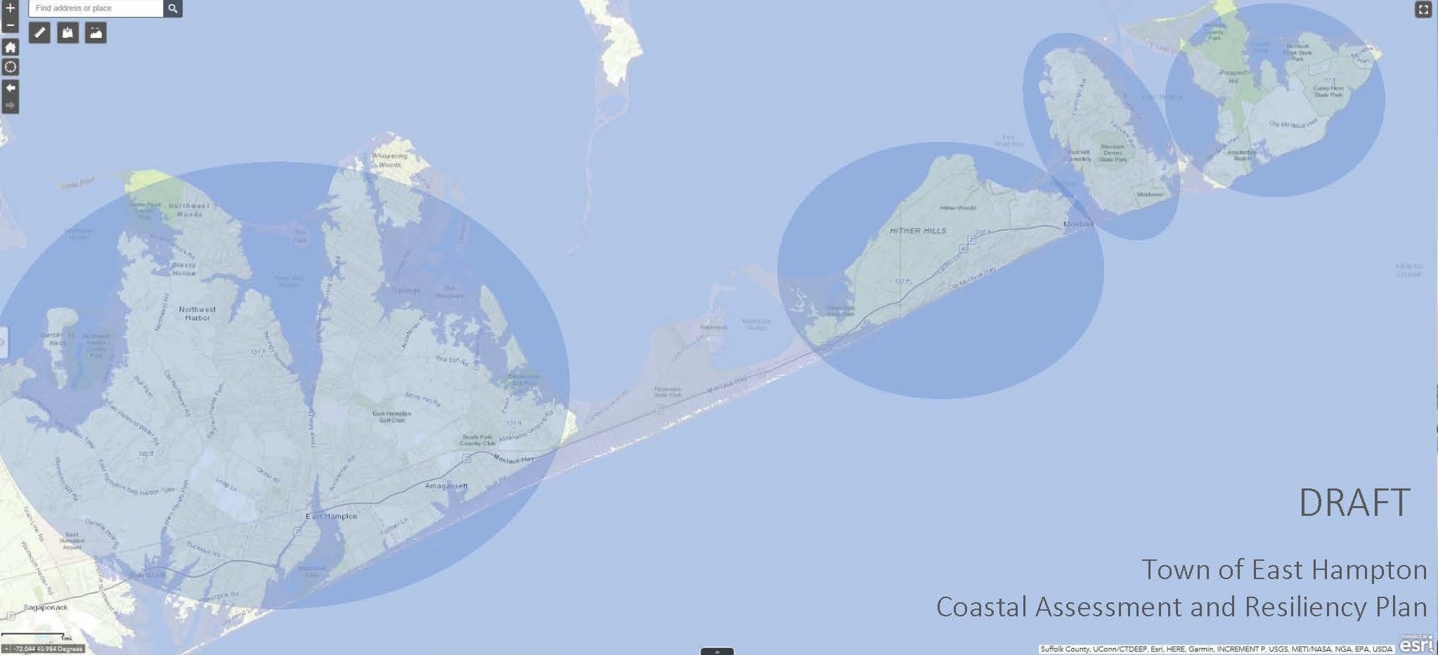
CARP map shows East Hampton Town could be split into islands if seas continue to rise, as they are projected to.
Consultants for East Hampton Town have completed a two-year assessment of East Hampton Town’s shorelines and their vulnerability to rising seas and severe coastal storms, as the town looks for ways to gird itself against the long-term effects of climate change.
Building on the work it did with the town’s hamlet study, development consulting firm Dodson & Flinker has presented the town with a sprawling report, hundreds of pages long, that explores the conditions and long-term expectations for nearly every inch of the town’s miles of shorelines.
Dubbed the Coastal Assessment Resiliency Plan, the report details threats to community centers like downtown Montauk and to very low-lying corners of the town and examines how they might be impacted by rising sea levels and how best the community can prepare for that over time.
“Sea level rise will physically transform East Hampton,” a committee of town officials, consultants and community leaders, warned in its draft report, which it will present to the Town Board next month. “Over the next 50 years, low-lying areas will be permanently submerged under water and the town will become a series of islands if we don’t take action now. The need to begin resilience projects and policies is urgent.”
Since early in their work, the consultants have based their work on three main strategies the town can employ in various areas depending on how dire the threat from rising seas will be: protection measures to defend against damage from intermixed flooding and to prevent erosion; accommodation, or acceptance that flooding will occur in some areas at manageable levels that allow infrastructure, private property and natural resources to weather the onslaught; and “managed retreat,” which is the relocation of development in areas where the threat of damage to property or infrastructure will become unavoidable and cannot be wholly guarded against without extraordinary measures.
Front and center to the plan’s conclusions is the acceptance that the town will need policies to guide and incentivize a “managed retreat” of development away from shorelines in some especially vulnerable areas — most notably downtown Montauk. Zoning changes and transferable development rights will be key components to allowing the needed shifts to take place over decades, and will themselves take years of analysis and planning to craft and put in place.
“The work must start now so these measures are in place when the need arises,” the CARP committee implores in its letter.
In rare instances, the report acknowledges, protection from extreme events may be needed and warrant taking drastic steps. For instance, the report suggests that a hardened “levee” could be constructed between Fort Pond Bay and Fort Pond along Montauk’s northern shoreline.
The coastline there is relatively stable under normal conditions but, at a maximum of just 8 feet above sea level, is vulnerable to a washover by storm surge during a major hurricane, which could cause extensive “backdoor flooding” and damage to critical infrastructure and the downtown area.
The report sketches out a levee running through the low-lying strip of land between the two water bodies, along the Long Island Rail Road tracks, from approximately Shore Road to where the land rises again behind the Rough Riders condominiums.
In other areas, the threat of increased storms will simply mean that some ill-planned development will simply have to fade away, with the town acquiring land that becomes unusable as sea levels rises. Portions of Lazy Point and Gerard Drive can expect to lose significant portions of what is now land but will some day be underwater and maintaining structures will not be feasible.
The CARP report, like the Hamlet Study, is not a legislative document or blueprint for new lawmaking, but is intended to be a handbook for town officials and the community as they try to craft common sense and realistic ways to help the region evolve and mitigate the unavoidable realities of sea level rise for coastal regions.
“The delivery of their Coastal Assessment Resiliency Plan is not an end; it makes the beginning of comprehensive coastal resilience for East Hampton,” the committee’s message reads. “The clock is ticking, the sea is rising, and our work is just beginning.”


 Michael Wright on Apr 27, 2022