


Residents survey damage after a 2016 storm. KYRIL BROMLEY
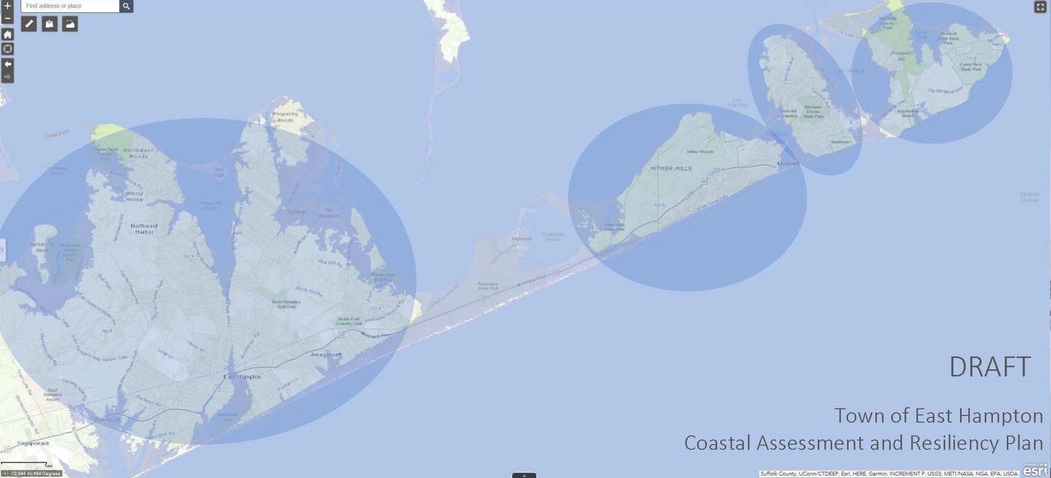
If no action is taken to combat climate change and sea level rise, this image represents the Town of East Hampton in as early as 2070, transformed into a series of islands shown as elliptical shaded areas. COURTESY TOWN OF EAST HAMPTON
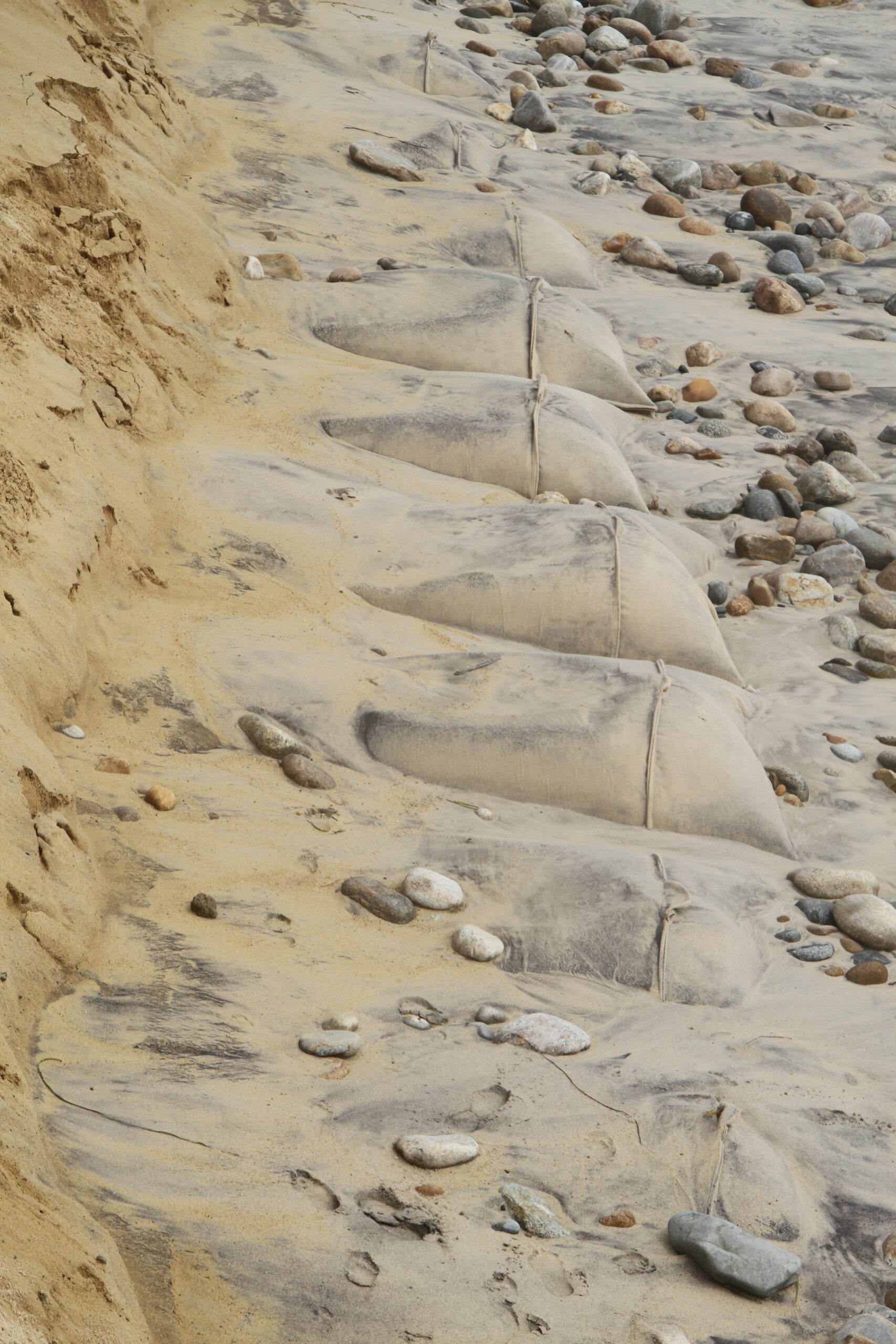
Exposed Sandbags after a storm.
Exposed Sandbags after a storm.
Exposed Sandbags after a storm.
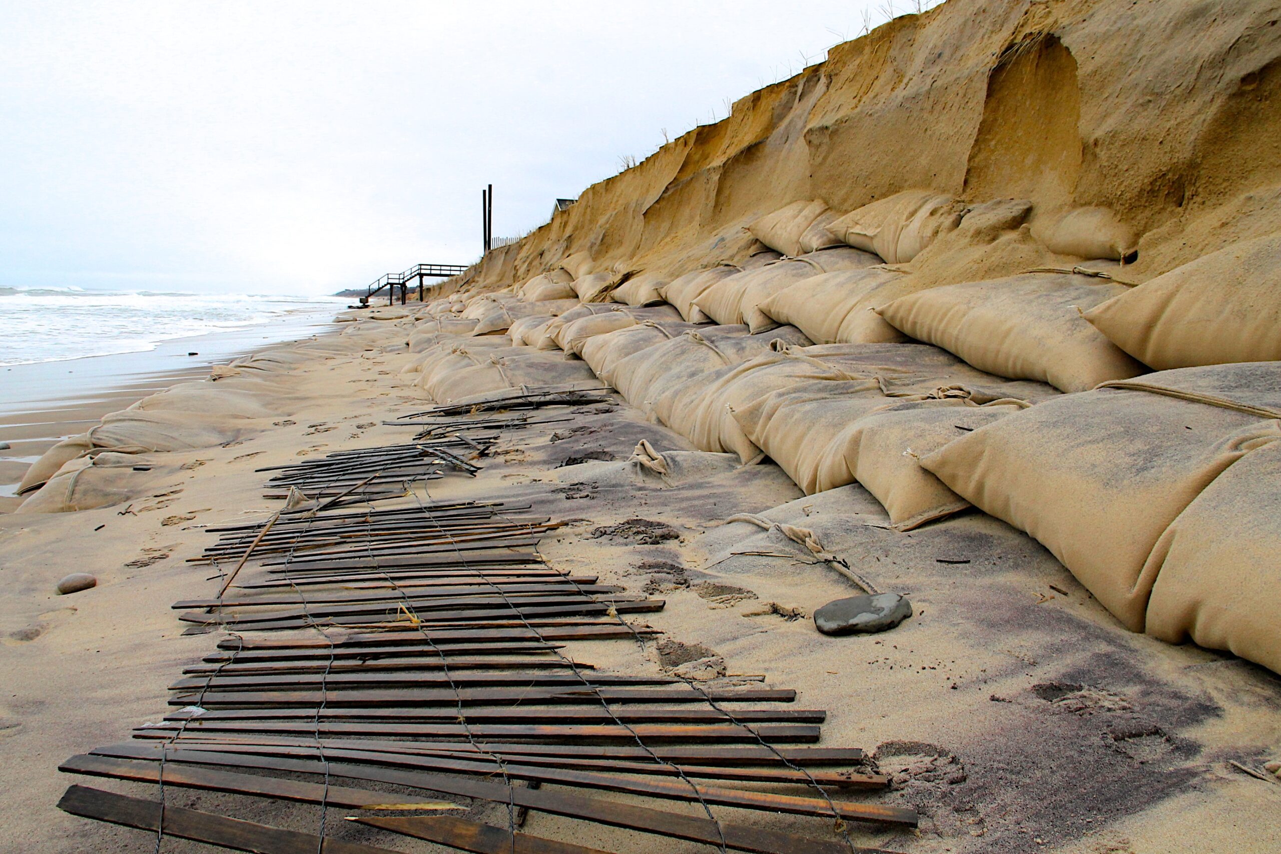
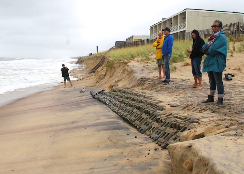
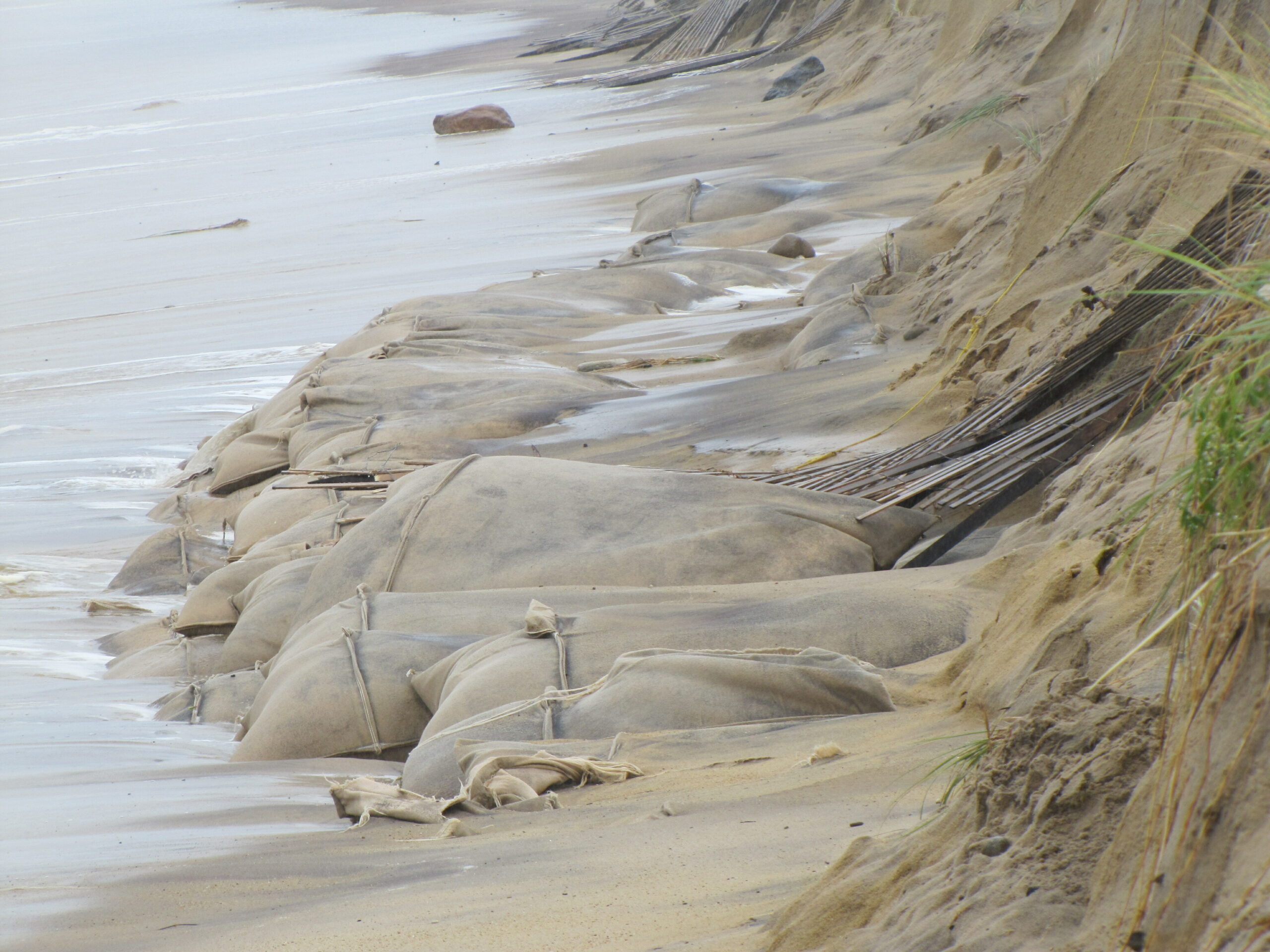
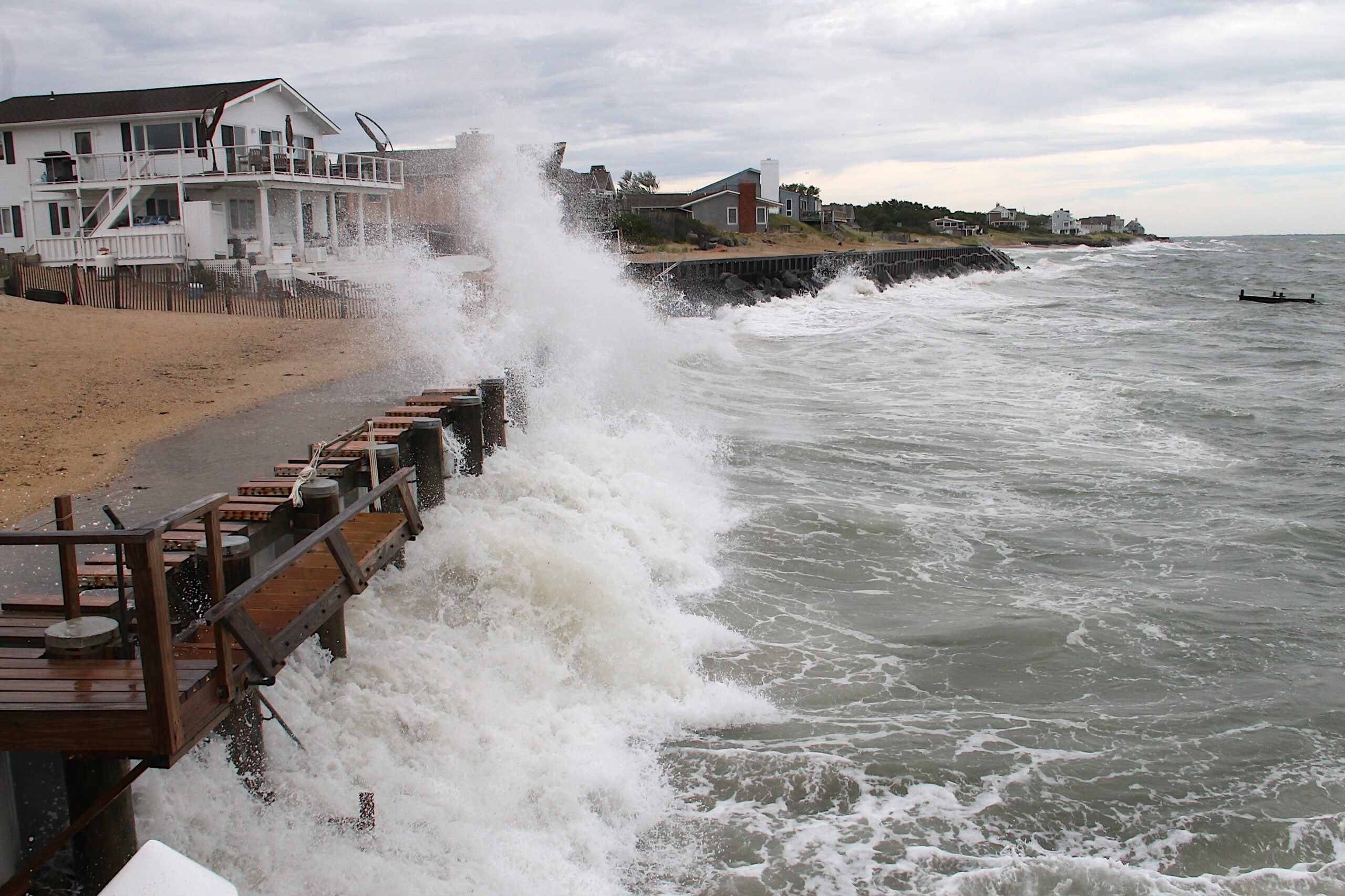
Exposed sandbags after a storm in Montauk. KYRIL BROMLEY
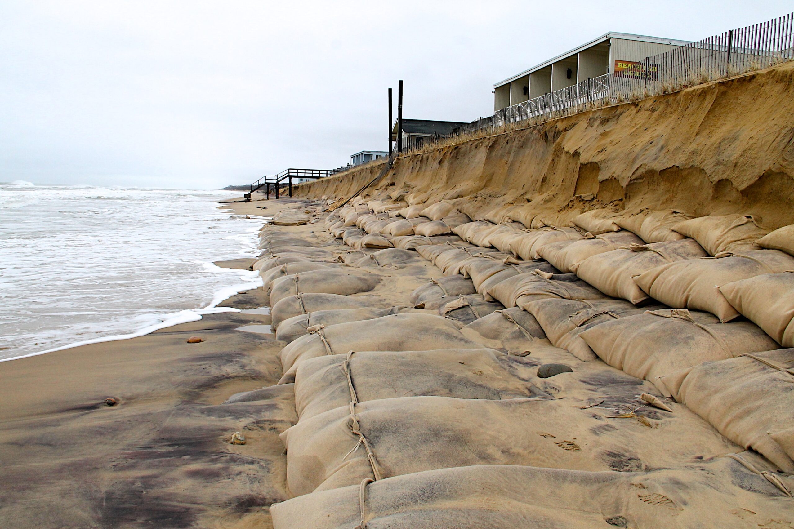
Exposed sandbags after a storm in Montauk. KYRIL BROMLEY
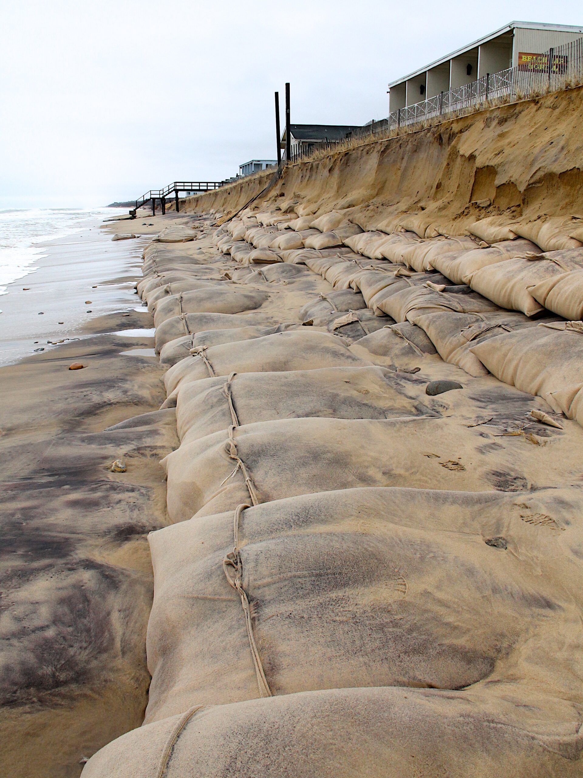
Exposed sandbags after a storm in Montauk. KYRIL BROMLEY
Montauk during a storm.
A century ago, a smattering of about 50 wooden shacks dotted the water’s edge in Montauk. They were home to 300 people, mostly commercial fishermen from Nova Scotia and their families, who transformed the alcove into a vibrant village — complete with a school and restaurant, a post office and bar, a telephone exchange, a store, and a pier that could house 30 boats.
Life, for a time, was simple enough, albeit rough — without running water, light or electricity to power the village, which relied on coal from the nearby railroad for heat and the adjacent dune for shelter from wind and storms.
But it wasn’t enough.
When the Hurricane of 1938 slammed into the East End, it swept through the small village and ripped it to pieces, taking most of the ramshackle homes along with it — splintering the burgeoning community that hugged the low-lying arc of Fort Pond Bay.
While some residents attempted to put their houses back on their foundations, many declared the area unsafe and vowed never to return, moving their boats to Lake Montauk, which founded the current Montauk Harbor fishing village — kickstarting the eventual disappearance of the Fort Pond Bay community altogether.
This isn’t the only piece of Montauk history lost to the sea during extreme weather events, according to East Hampton Town Supervisor Peter Van Scoyoc. To this day, after a heavy scouring at Ditch Plains, remnants of foundations once belonging to hotels and Coast Guard stations peek out from under the lapping waves — a ghost of what was, and a specter of what could once again be if climate change continues at its current pace, experts say.
“Sea level is rising at a much faster rate, and it’s predicted to increase over the next 80 to 100 years,” Van Scoyoc said. “If we look back over the past 100 years, downtown Montauk had another whole road parallel to the ocean called Edgewater — and guess where it is? It’s underneath the Atlantic now.”
“It’s inevitable, I think, in low-lying areas, with sea level rise and erosion, that some of those areas will be lost to us,” he added.
Wedged between rising waters from both the ocean and the bay, Montauk’s downtown and low-lying residential areas — positioned on a narrow strip of dunes and marshland — are at the crux of the discussion surrounding climate change on the East End, perhaps more than any other hamlet in the region.
Last Friday, East Hampton Town released the latest version of its Coastal Assessment Resiliency Plan, or CARP, a planning tool that identifies key coastal risks and examines how the hamlet should plan to guard against and adapt to them in the coming decades, according to Alison Branco, acting director of climate adaptation for The Nature Conservancy New York, who sits on its advisory board.
“Essentially, we’re already in a really big problem in Montauk. We’re at that emergency point already,” she said. “If I owned a hotel or motel on the beach in Montauk, I’d drive in every morning wondering if it was still gonna be there.”
In less than six months, October 22 will mark 10 years since Superstorm Sandy left an irreversible mark on the East End — physically, among the towns, villages and hamlets that dot the Long Island coast, and in the memories of those who were here to experience it.
The hurricane lashed the East End with winds as high as 90 mph, decimating miles of ocean beaches and leaving more than 65,000 South Fork homes and businesses without power. Towering waves crashed on the shores and the storm surge flooded low-lying areas — the worst effects of the storm, locally, felt in Montauk, where the ocean washed freely through gaps in the dunes at several access roads and some beachfront hotels saw dramatic damage.
“The whole front row of hotels was basically teetering out over the ocean. Literally, the beach was gone. Some of the swimming pools collapsed into the beach,” Van Scoyoc recalled. “I have noticed a definite shift in people’s perception about the coastline and the threat since Hurricane Sandy. That kind of made it more real for people.”
Despite the level of devastation, Superstorm Sandy’s impact was considered just a glancing blow to the East End — and nothing compared to the fury unleashed by the Hurricane of 1938. According to CARP, the chance of experiencing a flood event with a magnitude similar to that, at least once over the next 30 years, is about 60 percent.
That does not bode well for Montauk, Branco said.
“Montauk is super vulnerable. Montauk is the picture of vulnerable,” she said. “It’s a low-lying area, it has water coming from both directions, plus up underneath in the groundwater. And if you zoom out and look at Long Island, Montauk is ‘the end.’ It is the very tip of a long, skinny peninsula sticking out into the middle of the ocean.
“If you imagine storms coming up the East Coast, the way our continent is shaped, they come up along the shoreline and then they run into Long Island,” she continued. “So you can imagine how vulnerable Montauk is to those big storms — not to mention just the more chronic sea level rise impacts.”
In February, a report by researchers from the National Oceanic and Atmospheric Administration said that the United States is expected to see as much sea level rise as it has over the last century — which, for many coastal communities, means 10 inches to 1 foot, on average — by 2050. By 2100, that number could reach as high as 7 feet, though the report noted that these long-term estimates are less certain.
“You can debate all these different models out there, but at the end of the day, it doesn’t matter because they’re all saying the same thing in the end,” said Laura Tooman, executive director of the Concerned Citizens of Montauk. “It doesn’t matter what the numbers are because they’re continuing to get worse.”
If no action is taken, the rate of sea level and water temperature rise — compounded by increasing flood frequency and intensity, and accelerated shoreline erosion — would be devastating to East Hampton Town. A chilling graphic in the CARP draft report shows what the region could look like as early as 2070, marked by tidal flood inundation and areas of permanent submergence — including parts of Springs, Montauk and all of Napeague.
“If predictions of 6 and a half feet of sea level rise by 2100 come to pass — and it could be even more than that — there’s a good chance that we’ll have a series of Montauk islands,” Van Scoyoc said. “That is the natural progression of what’s happening.”
Back in the 1960s and 1970s, the homes in front of Soundview Drive and Captain Kidds Path had anywhere from 100 to 200 feet of beach in front of them, Van Scoyoc said. Today, that sand is gone. Residential areas near Fort Pond Bay, Lake Montauk and Ditch Plains are also areas of particular concern, he said, where water has breached on both sides of the land bridges during storms.
“People have to keep in mind that if you have waterfront property, you’re really only renting it from the Atlantic Ocean or Block Island Sound. That landlord may evict you at some point, and people need to be cognizant of that when they purchase properties,” he said. “Try to envision moving them back or raising them up — or understand that, at some point, they may go away and you may not have the ability to rebuild them.”
But the impacts of sea level rise, as they touch down in East Hampton Town, are not restricted to shorefront areas, explained Director of Planning Jeremy Samuelson.
“There is a corresponding rise between sea level and groundwater; the water table rises in a one-to-one ratio with the rising sea level,” he said. “In addition to us having real concerns about what can we build and where can we build it in a near-shore area, in low-lying areas that aren’t necessarily on the shoreline, we have a very real set of concerns about what will the impacts be of a rising water table.”
Those impacts are already happening, according to Kevin McAllister, founder and CEO of Defend H2O, a nonprofit dedicated to protecting Long Island’s various bodies of water. Sunny day flooding, where areas of lower elevation are overwhelmed with water during full and new moons, is prevalent in Montauk, where a higher water table also means that lawn chemicals and septic systems are sitting in groundwater.
“It’s a daunting issue,” he said of the impacts of climate change as a whole. “To make the decisions today that are going to benefit 30, 40, 50 years out when we just don’t see the urgency, they’re reticent to do it because there’s such political heat.”
When considering the impacts of climate change on Montauk — sea level rise and fast-eroding beaches, shrinking shorelines and sunny day flooding, an elevated water table and declining water quality — the answer needs to be a multi-pronged approach, environmentalists agree.
“Things are already starting to happen to try to combat those problems and try to protect the people and the businesses and the homes in Montauk from those problems,” Branco said, “including putting a lot of sand on the beach to try to put back all the sand that the ocean is eroding, as fast as it can, because of sea level rise.”
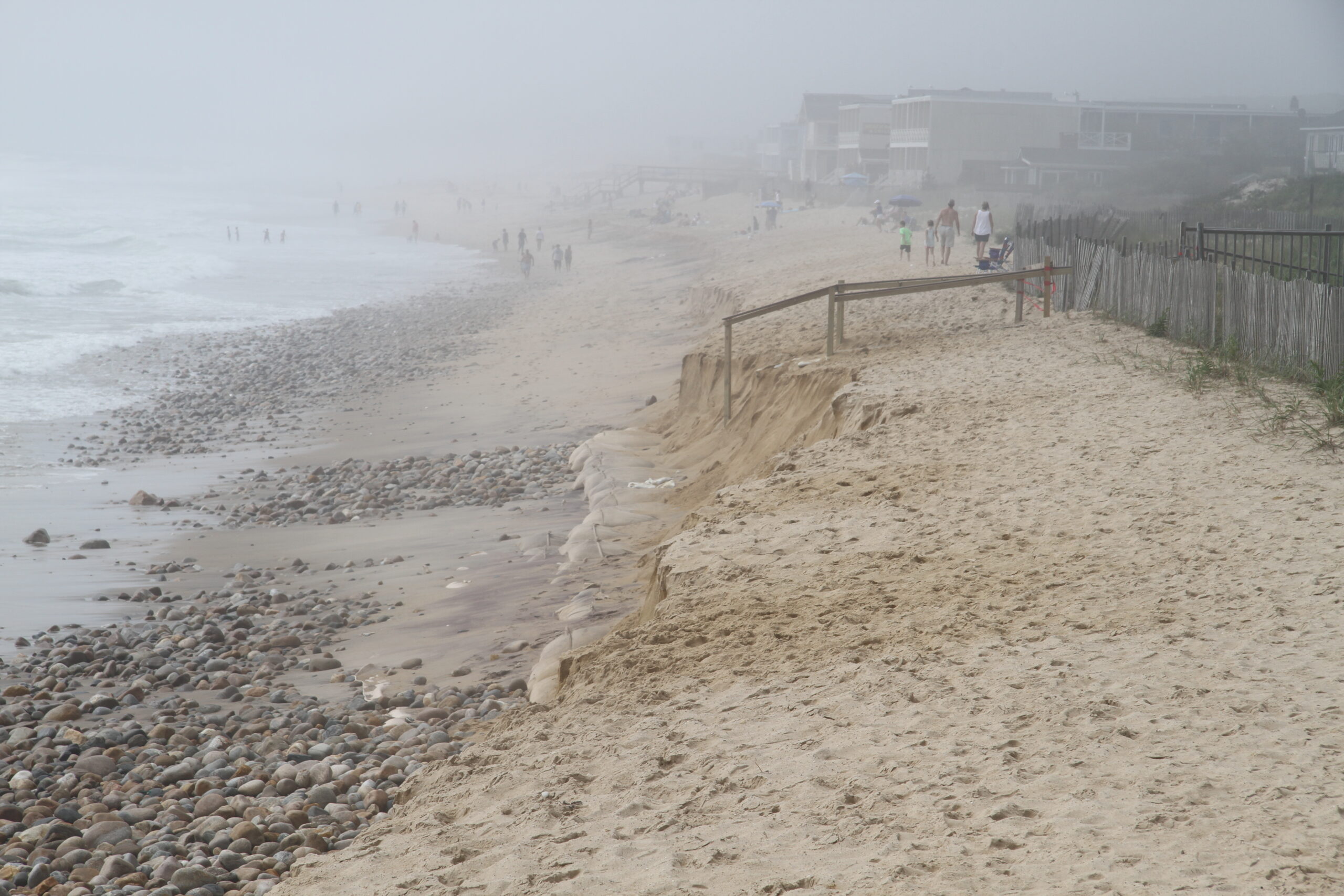
In 2015, three years post-Sandy, hundreds of Montauk surfers took to the beach to protest the Downtown Montauk Emergency Stabilization Project, which placed 14,000 1.7-ton geotextile sandbags along more than a half-mile of compromised shoreline, which were then covered by about 3 feet of sand, to the tune of $8.9 million.
Ultimately, Defend H2O, along with The Surfrider Foundation, failed to stop the project from happening, said McAllister, a staunch critic of sand replenishment projects.
“For the system to function and to have a sustainable beach in there, we have to restore a real dune system, in conjunction with the beach,” he said. “We need to put back a primary dune that can provide natural replenishment of the fronting beach.”
Set to begin next year, the long-awaited Fire Island to Montauk Point Reformulation Study, or FIMP, will dump millions of tons of sand along 83 miles of Suffolk County oceanfront — a project that will cost the federal government more than $1.5 billion for what is widely regarded as a temporary solution, Branco said.
“What’s really important is a recognition by a lot of folks that some solutions are short-term in nature and some are long-term in nature, and what we really need for Montauk is a combination of those two,” she said, adding, “Hopefully over the next 20 years, while we’re continuing to put sand on the beach to keep things safe for now, we’ll start to see all these longer-term solutions getting implemented.”
The CARP draft — which Van Scoyoc said he anticipates will be presented to the East Hampton Town Board for adoption this spring — offers a range of immediate action plans, from living shorelines and raising structures to altering town building codes in vulnerable areas to reduce future property damage.
“If one owner says to themselves, ‘The flooding is too bad, I don’t want to live in this building anymore,’ the last thing you want to see is them sell it to some other family, to invest all of their money into that place, and then find out that it’s also not suitable to them,” Branco said. “Once it gets to that point where it just feels unlivable for the people there, if possible, you want to try to get it out of residential development.”
She urges the use of the Community Preservation Fund to purchase properties that would be dedicated to “managed retreat,” which includes relocation and/or property acquisition and conversion to conservation land. The report said community outreach and funding should start now, but implementation would, for the most part, not start for another decade due to town and property owner challenges.
“We all have to understand that our relationship to the shoreline has to be reset,” Samuelson said. “The coastline itself is resetting, and we have to respond accordingly. So the simple truth is that not everything that currently exists will be able to exist in that same place, in its same form, forevermore.”
Part of the hurdle will be overcoming the negative connotation associated with the word “retreat” — Van Scoyoc said he himself “cringes” whenever he hears the term — not to mention the sheer logistics and the financial and emotional implications that come from moving away from the shore.
“Even if you don’t own a hotel on the beach in Montauk, that whole vibe of downtown Montauk is part of your lifestyle, part of where you live, part of what you identify with it, so it’s very personal and very emotional for folks,” Branco said. “It’s just really hard to envision it being as great, but looking different, and that’s natural — but that’s where we need to put our work in, in the near future.
“We need to get the community together to envision, ‘Okay, if we can’t have it look exactly like it does today, what would we want it to look like? What’s our new vision for Montauk?’”
The Planning Department will be integral to this process, Branco said, and she emphasized that the entire community needs to get involved in these conversations — not just business owners, but local residents, too.
“It’s easier to not talk about hard stuff,” Samuelson said. “And what we’re finding is when we don’t have the hard conversations before the time comes, it’s really hard to make important decisions when they’re needed.”
“What we know is that the world is changing and we cannot continue to have the same response and believe that we’re going to somehow fare better than we have up until now,” he added. “We literally have to bring new tools and new options to the table.”
After reviewing the CARP draft, McAllister said he is hopeful — though he quickly pointed to a number of management plans that have fallen by the wayside, including the Montauk hamlet study, the Local Waterfront Revitalization Plan and Comprehensive Plan in East Hampton, and Peconic Estuary Partnership Comprehensive Conservation Management Plan.
“I see that some of the concepts I’ve been repeatedly speaking to have been incorporated in the plan. I’m pleased to see it in writing, but will hold the applause,” he said of CARP. “Well-founded management actions identified in countless resource protection plans too often languish because the political courage required to execute wanes quickly with pushback from opposing interests. Nevertheless, reason for reserved optimism.”
From year to year, season to season, Tooman watches the Montauk coastline shift — as a seemingly healthy beach is washed away by a small nor’easter, until it is replenished once more — “and it’s a continual reminder that what is going on is just not sustainable,” she said.
In Montauk, a few of the tiny wooden shacks remain from the old Fort Pond Bay fishing village, marking the edge of what used to be a thriving community — one that, after the Hurricane of 1938, considered the future of its ravaged built environment and decided to leave it behind.
“I think we have to look at what the lessons of history are here,” Samuelson said. “People did the sensible thing and asked, ‘Should we just rebuild the same place that is in the same place, or should we move?’ And they came to the right conclusion and said, ‘We will fare better over time if we move.’”
“Ultimately, the final arbiter here is Mother Nature and none of us, of course, can control that,” he added. “All we can do is work together to come up with a sensible response to the changes that are happening around us that allows us to preserve the things that we value most.”


 Michelle Trauring on Apr 28, 2022