


Storm damage on Montauk Highway in Shinnecock Hills after Hurricane Irene. DANA SHAW
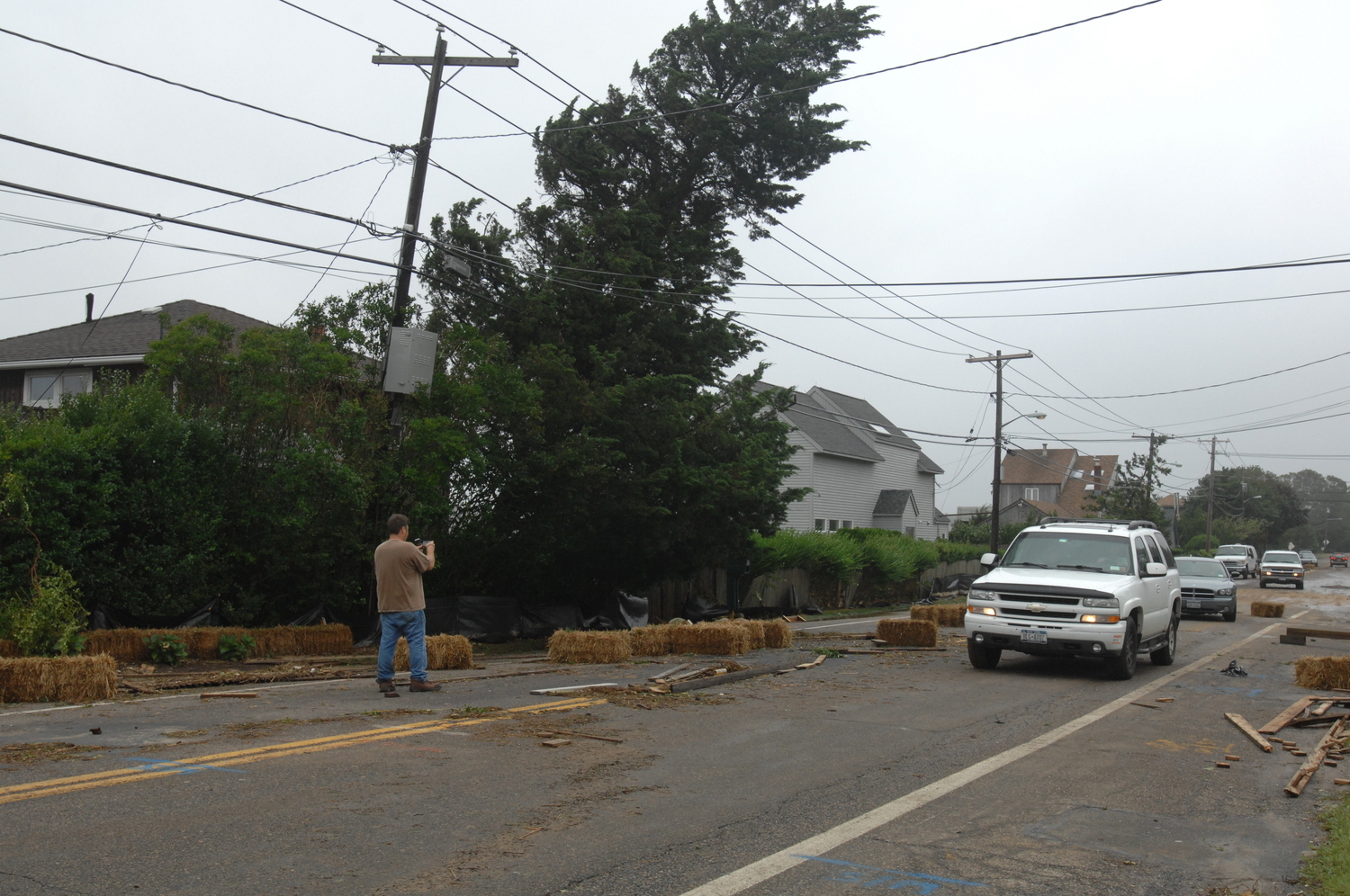
Storm damage on Montauk Highway in Shinnecock Hills after Hurricane Irene. DANA SHAW
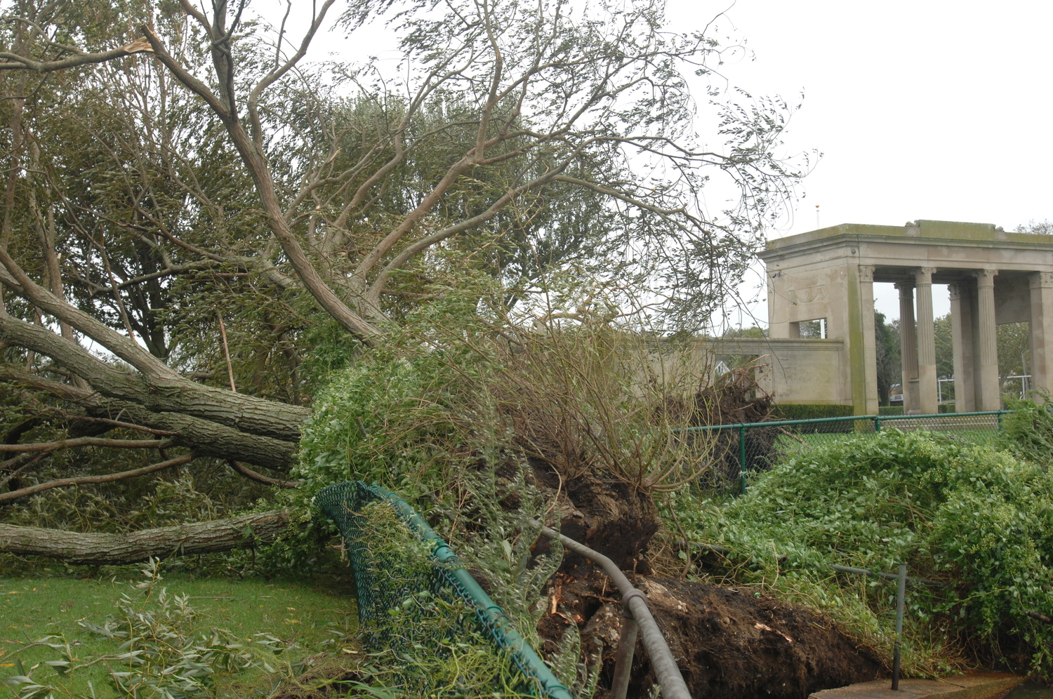
Storm damage in Southampton Village after Hurricane Irene. DANA SHAW
Storm damage in Southampton Village after Hurricane Irene. DANA SHAW

Hydrangea damage from Hurricane Irene in 2011. This was 24 hours after the storm, salt spray and inundation on Meadow Lane in Southampton. The next day the plants dropped all their foliage and were dead. ANDREW MESSINGER
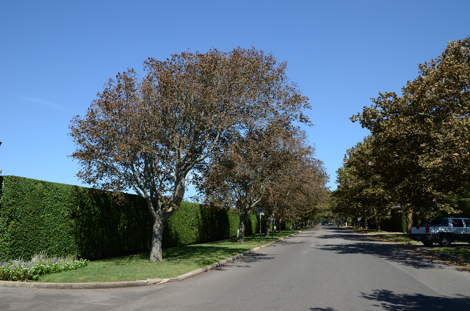
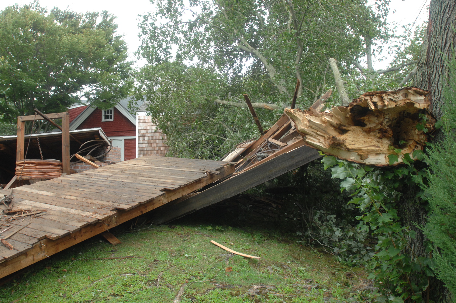
This is how the linden trees looked along Coopers Neck Lane in Southampton Village the morning after Irene. Smaller, recently planted trees were totally uprooted. These trees re-leafed about a month later. ANDREW MESSINGER

Privet hedges along the street near the ocean after Irene. Behind the privet, taller trees and shrubs that were not shielded were completely burned and defoliated. The taller the tree the worse the damage as you can see on the far right. ANDREW MESSINGER

It’s been many years since the East End has had to deal with a substantial hurricane, and if you believe the forecasts for this hurricane season this could be our best chance for a hit in decades. And while I can’t tell you the odds, I can give you some pointers on how to get your property, landscape and gardens ready.
It’s important to be aware of where one of these storms can come from and how it hits the East End and where it will hit. But a direct hit isn’t all we have to deal with since a near miss can still cause catastrophic damage. And yes, you can and should get ready and be proactive. Those of you who have lived out here for a few decades know the drill. Those of you who are newer to the East End may find this column very helpful.
In addition to the high number of storms forecast through October the trend seems to indicate that we are in a special and dangerous circumstance. This season the atmospheric and oceanic conditions that usually cause most East Coast storms to veer or recurve back out to sea well south of here and miss us … well these elements are absent this year, making our risk even greater.
When a hurricane or tropical system approaches Long Island it’s all about location, location, location. Some storms cross the middle of the island, resulting in little more than a stiff breeze out here. Just 50 miles west of us there can be major flooding and wind damage. There have also been storms that have traveled over the far eastern end or east of Montauk, resulting in little to no damage in Southampton and just wind in East Hampton and Montauk.
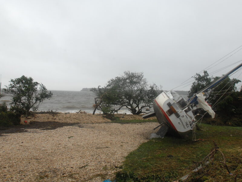
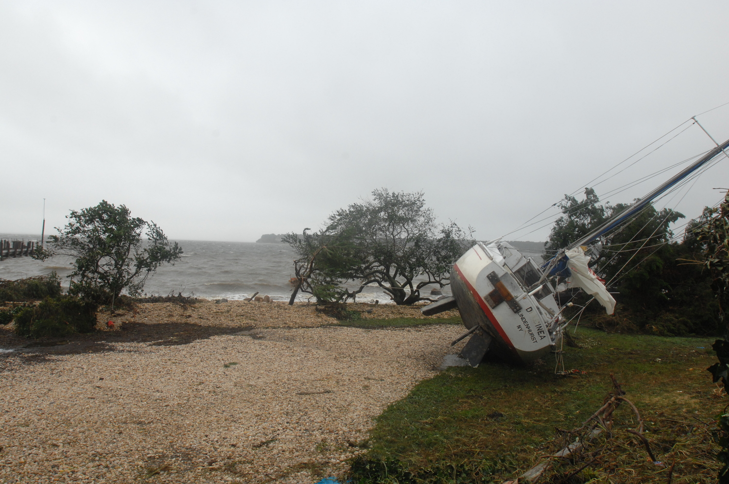
You also have to consider the size of the storm in width, intensity and where the rain is likely to fall since not all parts of a hurricane are wet. One of the worst situations I can remember is a storm that came in and was totally dry. This was hurricane Irene in 2011 in late August. The storm traveled over Nassau County, but it was very large storm. All the rain was west of us but the wind on the east side of Irene was directly off the ocean. The wind intensity resulted in the storm picking up ocean salt spray from the turbulence and bringing the salt spray as much as a mile inland … to us.
The result was as if salt had been sprayed over the landscape and coated everything. What we saw was trees and shrubs that were totally burned by the salt. Yes, there was some flooding as the storm raised shoreline water levels and the barrier beach areas of Southampton and Westhampton were flooded, but the lasting damage was from the wind-blown salt.
The salt spray burned the foliage off fruit trees, shade trees and even burned some sturdy and resistant Japanese black pines whose needles were burned. It looked like a bomb had been dropped in Southampton, and from Montauk Highway and in some cases Sunrise Highway to the east there was damage. Within 48 hours there wasn’t a leaf left on privet hedges and most shade trees along main and side streets. And of course, there was the hurricane of 1938, which resulted in the ocean breaking through in Hampton Bays creating a new inlet which is now the site of the Shinnecock Inlet.
During another storm, when I was working at Southampton College, we went outside just as the storm passed, and even then I remember finding it difficult to walk while the wind pushed against me. Montauk Highway at Tuckahoe Road was under several feet of water, and large boats washed up onto the yards of the properties south of the highway. Even the trunks of palm trees showed up along the ocean beaches and some Shinnecock Bay home yards.
So now is the time to survey your property and make a list of priorities should a storm be imminent. But there are things you can do now, this week, to prepare. Look at your property and imagine that every tall tree near your house or outbuildings can become a missile or fall and tumble. Dead limbs can become airborne, and if there’s a good deal of rain before the storm the rain loosens the ground while the foliage on the trees becomes a sail that catches the wind. Will that tree hit your house? Now is the time to have a certified arborist take a look and make suggestions. Yes, insurance may cover the cost of damage. But insurance can’t stop you from being injured or killed. And if you’re negligent in taking care of a known risk you may be surprised at the insurance company’s response.
The most damaging part of a hurricane is generally around the eye or eyewall. This is where the strongest winds and heaviest rains usually occur, and you can gauge where the eye will pass based on weather reports. Consider though that the eye can wobble, disappear then reform. The eye can be small and tight, which is the worst case, or several miles wide. It’s important to consider that as a hurricane passes the wind direction shifts so in your analysis and thinking consider that the wind may come out of the south first then as the storm passes switch to the north. When the eye of the storm passes over you may see blue sky and there may be a nearly calm wind.
This is not the end of the storm. The second half is on the other side of the eye. There are several scenarios so consider them all. Damage can be caused by wind in any direction and the worst case is strong wind from one direction followed by a wind shift to the opposite direction. The wind can also be as damaging as the storm passes as when it approaches.
If there is rain it may be salt laden and even if the storm hits us with its dry side there can still be extensive and devastating salt damage. Some foliage will drop from the salting nearly immediately while the balance of the salt damage may take a day or two to see. There’s little you can do. The other issue is salt damage to lawns and soils. Kentucky bluegrass does not take well to salt damage. Some salt damage to roots can be mitigated by the use of gypsum but this will only work if your landscaper knows how to use it and when.
If you do have power and water after a salt-laden storm you may need to water the lawn and shrubs to attempt to leach the salt out. Some lawns will recover, bluegrass lawns won’t and will need resodding when possible and when the salt is flushed out. Hydrangeas used in the barrier beach home sites will also suffer, not just the salt spray but also from the saltwater flooding. They will mostly recover from foliar damage but it may take a year. Root damage from saltwater flooding will probably kill these plants though.
And when the blow comes anything that can move has the potential to become a missile hurtled by the wind. Part of your storm prep should be to get outdoor furniture tied down well or moved indoors. Any potted houseplants should be moved indoors. Lawn and garden furniture should be moved indoors as well as any garden ornaments and lanterns. In the vegetable garden you may want to harvest some vegetables like green tomatoes and nearly ripe melons as these can be ripened indoors after the storm. Store your garden hoses indoors. Yes, they will blow away in good gale and you will need them once power and water are restored.
When the storm passes be very, very careful when you go outside. Debris can be scattered from blocks away including glass, wood and timber. If electric lines are down, always assume they are dangerous and don’t go near them even if your power is out.
As for Irene, many trees refoliated within weeks of the storm. I recall defoliated apple and peach trees that were leafless came back to life weeks later and then bloomed in late October. Feeding these trees was critical to enable them to make it through the winter and rebuilt stores of carbohydrates that had been used up in releafing and flowering twice in the same year.
One little thing you may want to keep around is a NOAA weather radio — a battery-operated radio that has the NOAA frequencies on it. If the power goes out, cable goes down and cell towers fall or run out of generator fuel your NOAA radio will provide critical information. Keep growing and be prepared.
More Posts from Andrew Messinger


