


Ann and David Rhoades recently had a new nitrogen-reducing septic system installed at their home on the water in North Haven. Mr. Rhoades, a civil engineer, has been designing the systems for more than 20 years. CAILIN RILEY

Pretty Girl, pictured with trainer Mike Hinz, has been rehabilitated and is ready for a forever home. KYRIL BROMLEY

Southampton junior point guard Israel "Izzy" Johnson led his team with 28 points, six assists and four steals in a win over Malverne in the Long Island Class B Championship on Tuesday. CAILIN RILEY


Zach Cummings had 18 points for the Mariners and was a force in the backcourt, along with Israel Johnson. CAILIN RILEY


The Mariners celebrate their win over Malverne in the Long Island Class B Championship on Tuesday. CAILIN RILEY

Kate McEntee, adoptions director for he Southampton Animal Shelter Foundation, with one of the puppies from El Faro de los Animales, a shelter in Humacao, Puerto Rico, that was leveled by Hurricane Maria. The animals arrived on a chartered flight to Gabreski Airport in Westhampton Beach on Sunday. CAILIN RILEY

Amaza Lee Meredith, one of the founders of Azurest. COURTESY NEW YORK STATE HISTORIC PRESERVATION OFFICE

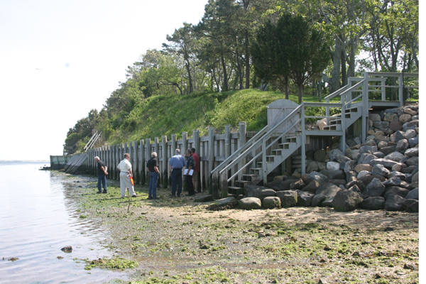
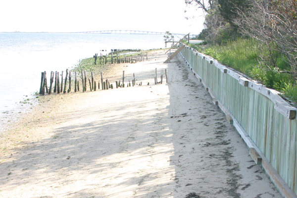
A stretch of badly eroded Hampton Bays shoreline recently became a classroom for a history lesson of sorts given by one of the Southampton Town Trustees, and also a spotlight on how the priorities and policies of managing coastal properties has evolved over the years.
From the years when Shinnecock Bay was a brackish enclosed embayment, through decades of informal but effective stabilization of the bay’s shoreline through methods now prohibited, to the era of soaring stalwart walls of wood and steel at the foot of multimillion-dollar mansions, the Trustees and representatives of nearby homeowners surveying damage to the protective structures meted out by Hurricane Irene walked through a veritable time warp during a low tide last month.
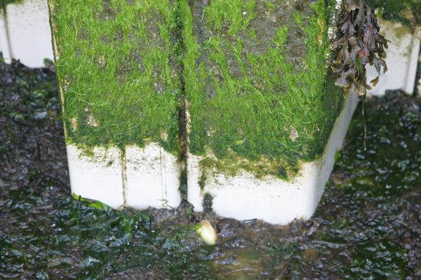
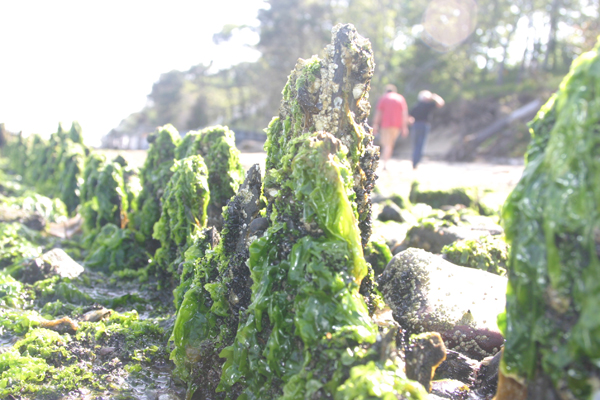
“In the 1920s, before the ’38 hurricane, the bay wasn’t tidal, and this was a big sailing area—there were four or five hotels, a casino, everyone had docks along the shoreline,” Trustee Ed Warner Jr., whose family has been working the waters of Shinnecock Bay for generations, told the other Trustees and two consultants while strolling along the damp sand of the southern end of Cormorant Point in Hampton Bays. He pointed to the seaweed-shrouded stumps of former dock pilings protruding just a few inches from the bay bottom, where they would be obscured by water except for a few hours each day. “In the old days, the brush jetties were maintained by the locals. They’d tie saplings together in between the pilings, and that kept the beaches somewhat stable for 60 years or so.”
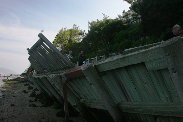
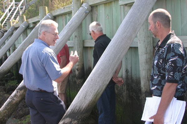
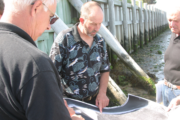
The five Town Trustees, attorney Michael Walsh and coastal engineer Ken Lindhauer were surveying a series of tall wooden bulkheads at the foot of several properties along Cormorant Point. Some of the bulkheads had been undermined by the storm surge and winds of Irene, and several homeowners have applied to the Trustees to either repair, replace or take additional steps to bolster the protection of their properties. The most dramatic failure of the bulkheads came at the foot of one property where the bulkhead bowed and leaned steeply toward the water, yanking out the steel and wooden planks that anchored it to the hillside.
“When the water gets over the top of the wall, all this turns to quicksand, and the deadmen just give out,” Mr. Lindhauer said, pointing and referring to the support planks that had been buried vertically in the hillside but were now lying asunder. “This happened in about two hours during Irene,” Mr. Warner added.
The consultants, who represent seven property owners along the shoreline, are asking that they be allowed to reconstruct some of the bulkheads entirely, burying them much deeper in the ground to give them more support, and bolster others with piles angled shoreward from the water side of the wall, called batter piles, to prevent the walls from falling seaward in case even of overtopping. They have also asked if the Trustees would approve the placement of rock wave breaks along the foot of the bulkheads in some places to absorb the force of waves slamming into the bulkheads, which could also ease the erosion of sand some.
The walk the Trustees took was possible only during the very bottom of a low tide, because the once-thin ribbon of sand that bounds the bay waters has effectively been erased. The bulkheads that line the shoreline have halted the retreat of the bluffs and protected the large houses atop them, but have caused the beaches to erode, because the collapsing bluffs were one source of the sand that formed the beaches as it was carried along the shoreline. One of the bulkheads that is now the de facto shoreline when the tide rises was originally built as an upland retaining wall along the bluff—25 feet from the high tide line at the time.
“You’ve virtually lost all the beach here, and it’s going to keep going—the only time you can walk along the shore here is on the lunar tides,” Mr. Warner said, gesturing to where the bay water lapped against the bulkhead of a neighboring property even at low tide, because it was not one of the exaggerated tides that come with the full and new moon cycles. “The sand in this area is very fine, and there is a very shallow slope to the beach, so any wave action at all just sweeps it right out.”
Before the bulkheads were built, the bluffs along much of Cormorant Point were eroding at a rate of nearly 1 foot per year, Mr. Lindhauer said. With properties now worth millions of dollars and large houses, swimming pools and intricate landscaping impossible to relocate as the bluffs retreated—it was a common practice in decades past—halting that migration was imperative.
The rate of erosion seemed to speed up sometime in the early 1990s, Mr. Warner said, surmising that a famous series of winter storms in 1992 and 1993 may have shifted channels and sandbars in Shinnecock Bay, redirecting currents or opening the shoreline to more wave action that magnified erosive effects.
“This is not that dissimilar to what happened at the North Sea Beach Colony,” Trustee Fred Havemeyer said, another site of erosion. “There’s no question that as time goes on there are going to be more and more of these hot spots.”
Mr. Warner agreed: “I think, eventually, the whole bay shore will look like this,” he said, gesturing to the bay’s northern shoreline, while standing atop one stretch of bulkhead where the water runs up to the foot of the wood wall.
The question is whether anything can be done to address the problem so that beaches and the access to the shoreline they afford—the Trustees’ primary interest in the stretch of beach—can be restored in some form.
As the entourage rounded Cormorant Point, walking to the south, they came upon a stretch of shoreline where sand once again rose up from the waterline to the bulkhead, and appeared to be enough to be dry even at an average high tide.
Mr. Warner pointed to where a dock and wooden ramp—built so a bulldozer could access the beach to work on the bulkhead of one house—bookended the stretch of shoreline, dampening the erosive effects of waves sweeping along the shoreline.
He also pointed out several wooden stumps, arranged in two parallel rows, protruding from the sand. The stumps, like the rotting dock piles seen earlier, were the remnants of rows of pilings buried in the beach that were stuffed with tree trimmings and brush, in order to capture sand and slow the erosion of the beach. These are the aforementioned brush jetties, which acted much like stone groins along ocean beaches do, capturing and holding sand between them. Until the 1970s, the brush jetties were maintained informally by local residents.
Such efforts, though effective, were outlawed as the state and local agencies began trying to halt the practice, since capturing sand from the natural flow can have harmful erosive effects down drift of the structures.
“It’s a good history lesson: Look what preserved the beaches for 60 years—brush jetties,” Mr. Warner said. “They kept the beaches somewhat stable.”


 on Jul 6, 2012