


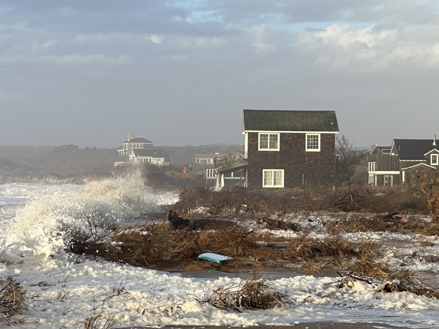
A trio of storms that all brought tropical storm force winds to the South Fork in the last month have washed away the last remnants of dunes that separated some homes from the ocean at Ditch Plains. Town officials are appealing to federal and state agencies to help bolster the area against further loss of land in severe storms. DOUG KUNTZ
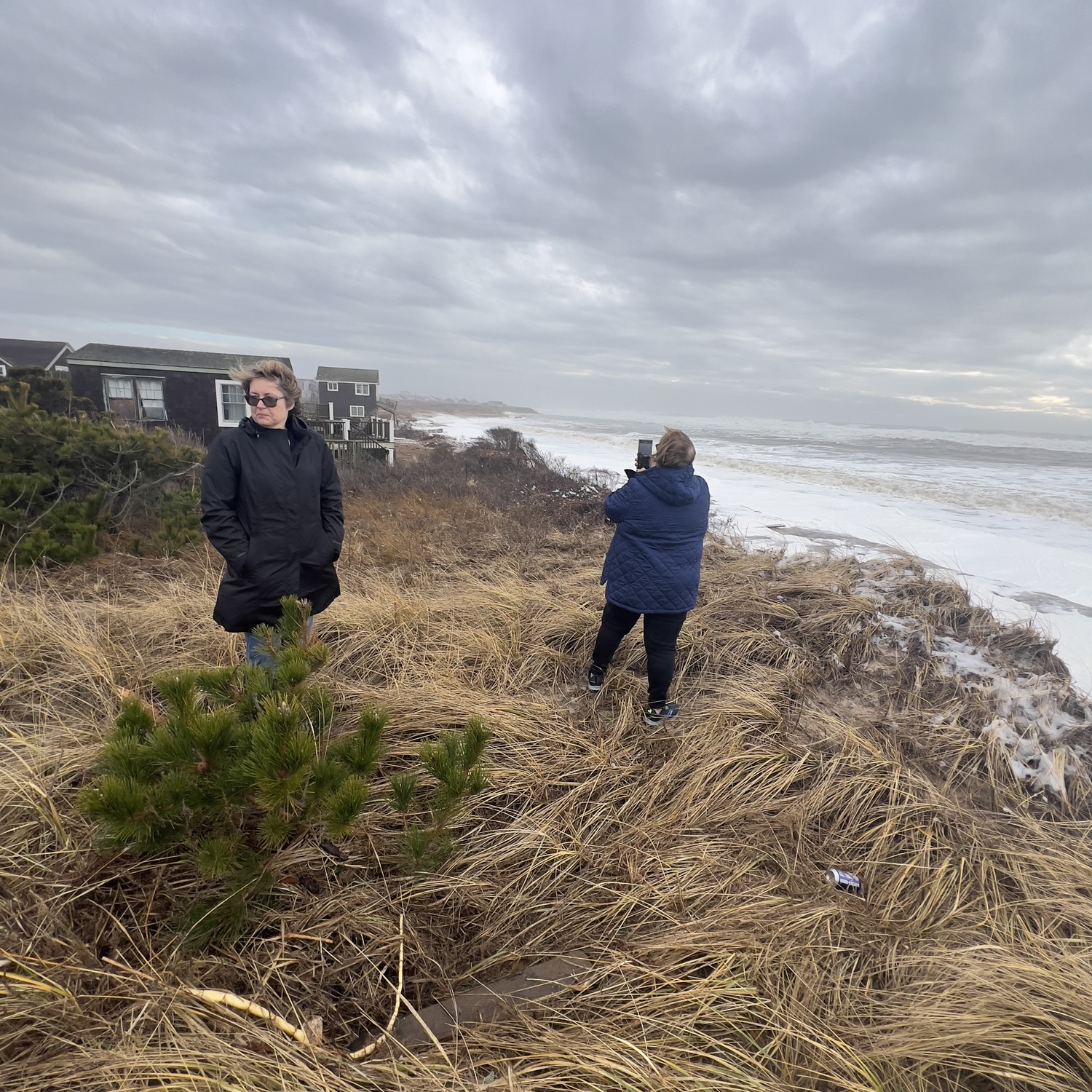
Supervisor Kathee Burke-Gonzalez and Councilwoman Cate Rogers survey the conditions at Ditch Plains during the second of three severe storms over the last month. DOUG KUNTZ
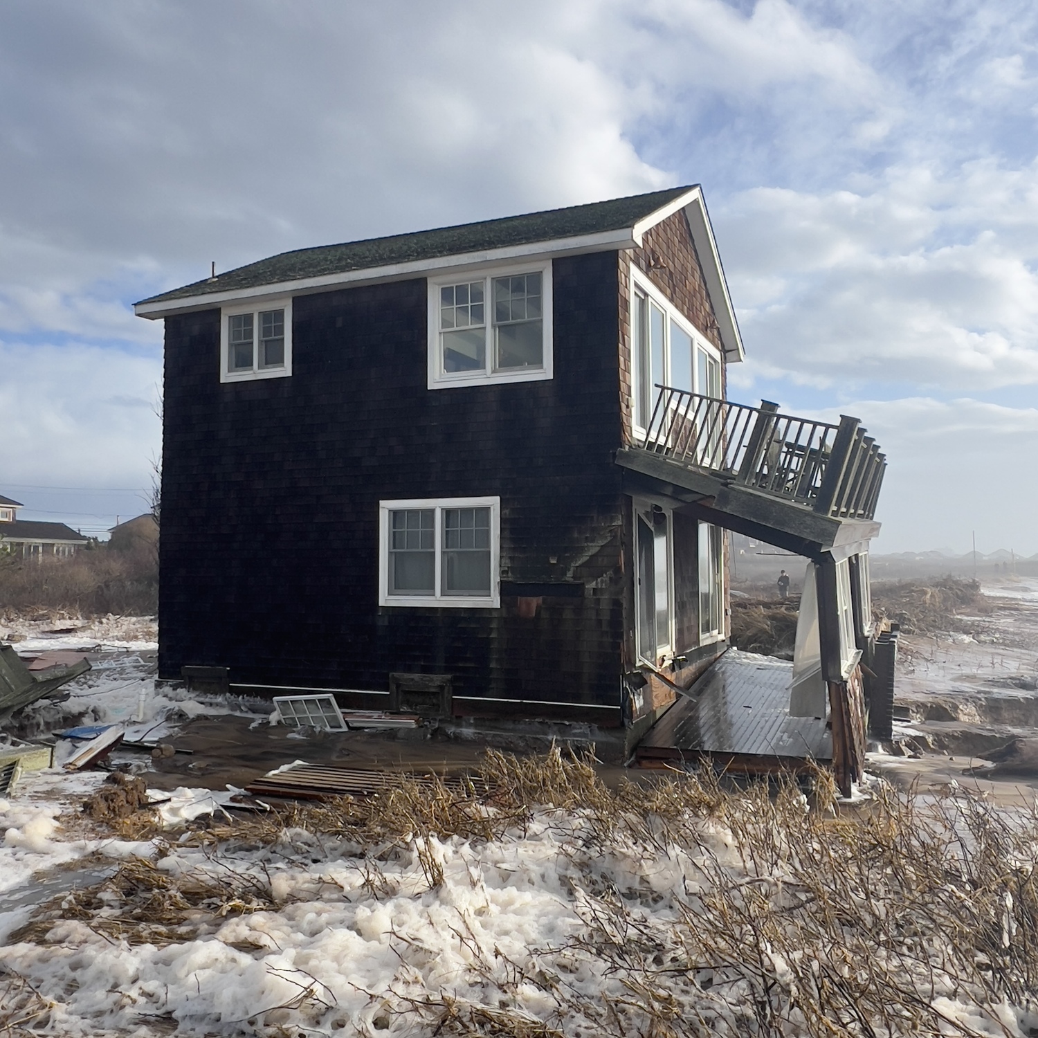
A home near the water at Ditch Plains was damaged in the recent storms and now has nothing between it and the water but the low beach. The owners have contacted town officials about what can be done to protect the home. DOUG KUNTZ
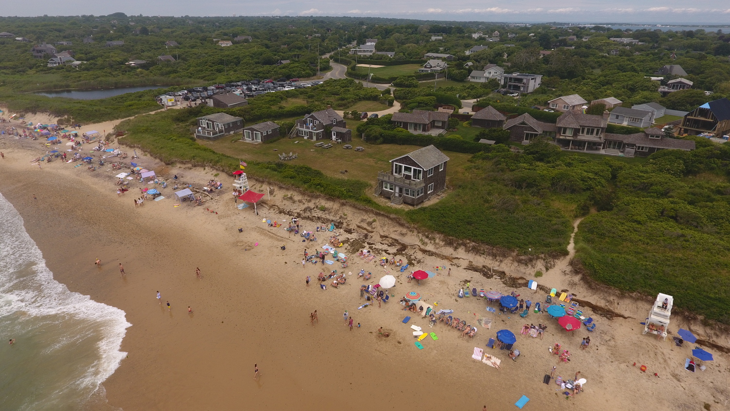
The area of Ditch Plains hit hardest by the recent storms had been precariously close to the shoreline this past summer. MICHAEL WRIGHT
A triple-whammy of strong nor’easters in the last month, following a stormy autumn, has left portions of the Ditch Plains neighborhood vulnerable to flooding and extensive property damage if something is not done to bolster the shoreline almost immediately, residents said this week, pleading with the East Hampton Town Board to find some way to protect the area.
Town officials said they have reached out to state and federal agencies and that the Army Corps of Engineers had said on Tuesday that it would “expedite” review of conditions in Montauk and on Fire Island in the wake of the recent storms and are exploring options for other actions that can be taken as a stop-gap.
“We, the residents and recreational users of Ditch Plains … urgently appeal to the East Hampton Town Board to take immediate and decisive action to address the critical loss of the protective dune at Ditch Plains,” Laura Michaels, the president of the Ditch Plains Association, said, reading from a petition that she has circulated. “We urge the town to find a comprehensive initiative for sand replenishment and dune restoration to safeguard the future of Ditch Plains.”
“The last three storms have been back-to-back, leaving us with no beach at Ditch and it’s only January,” echoed Kay Tyler, the executive director of the Concerned Citizens of Montauk. “With the frequency and severity of each passing storm, the situation is disastrous and unsafe for the public. We need to take action to find a solution.”
But the beaches in front of the neighborhood are in dire need of the sort of massive replenishment of sand and rebuilding of dunes that is unlikely possible on the small scale the town can muster, Michaels and Tyler acknowledged. They spotlighted frustration that the federal Army Corps of Engineers is due to spend $11 million this winter to pump more than 600,000 tons of sand ashore along Montauk’s downtown waterfront, but has refused to direct any effort at Ditch Plains.
Michaels said the town should renew its plea to the Army Corps to reconsider Ditch in its plans.
Supervisor Kathee Burke-Gonzalez said that she has invited Senator Charles Schumer — who has been vocal in his demands that the Army Corps address damage on Fire Island — and other state and federal officials to come tour Montauk and see the tenuous position it is in.
Michaels warned that if another severe storm were to come ashore in conjunction with a high tide, like the storm that hit on January 10 did, the flooding could reach residential neighborhoods inland.
Three storms have pummeled Long Island with tropical storm-force winds in the last four weeks, including two in less than six days last week. The storm on January 10 generated gusts up to 80 mph on the South Fork, generated ocean waves nearly 30 feet tall and pushed in a surge of water that swelled the high tide six feet higher than normal on January 10 and more than four feet on January 13.
In all, the South Fork has actually gotten off lightly in the damage inflicted by the recent storms. On Fire Island, the storm-driven waves — which neared 30 feet according to National Oceanographic and Atmospheric Administration data — breached the barrier islands and inundated entire neighborhoods on the northern shorelines of Great South Bay, damaging hundreds of homes.
The damage locally has been isolated to areas that were already suffering from severe erosion or have long been vulnerable to high tides swollen by meteorological conditions. Social media photos and videos spotlighting the damage in Montauk have amplified the destructive impacts of the waves but have focused largely on just two locations where water surged over dunes, damaged one home in Ditch Plains, washed piles of debris through a beach access cut and exposed the sandbag revetment built along 3,000 feet of downtown Montauk to protect the foundations of oceanfront structures.
Flood waters have also washed over roadways and into some neighborhoods on Gardiners Bay, most notably in Lazy Point and along Gerard Drive and Louse Point Road. Brian Frank, the town’s senior environmental analyst, said the town has seen two of the highest tides it’s ever recorded in the last month.
Town officials noted that nearly every place impacted by the recent storms was spotlighted in the town’s Coastal Assessment and Resiliency Plan, adopted last year after four years of study of the town’s waterfront. They said the recent onslaught should serve as the spark that pushes action on the recommendations in the plan for addressing the vulnerability of each area.
Councilwoman Cate Rogers said on Tuesday that the town needs to quickly put together action plans for when there is damage from storms — setting up a system for an expedited review of temporary measures that homeowners can take to protect their homes from an oncoming storm or recover from damage.
“We need to go out and talk to property owners about what [they] are allowed to do if we have a loss … we need to be inviting people to have this conversation with the town before a storm,” she said.
As far as steps the town can take for preventing damage in the first place, the options are few. In the short term, the town can use trucked-in sand to try to slow down the advance of the waves. Such efforts can have mixed results — a sand berm piled across a road ending ahead of the January 10 storm was obliterated by the waves, but the same effort held up to last weekend’s slightly less severe storm.
In the longer term, the board agreed to hire a coastal adaptation specialist to begin drafting a new set of guidelines for homes in vulnerable coastal areas, drawing on the recommendations of the coastal adaptation plan.
“As the frequency and intensity of storms change … we cannot simply continue with business as usual,” town Planning Director Jeremy Samuelson said. “We anticipated this. But now is the hard part. Now is the moment where we have to begin to behave differently.”


 Michael Wright on Jan 17, 2024