


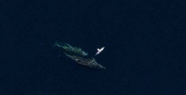
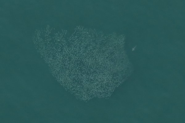
A shark pursuing a school of fish. Normandeau Associates/APEM Ltd. Environmental Imaging Solutions
The New York State Energy Research & Development Authority is conducting aerial photo surveys of marine life in the ocean south of Long Island where wind farm development is expected to boom in the next two decades. Normandeau Associates/APEM Ltd. Environmental Imaging Solutions
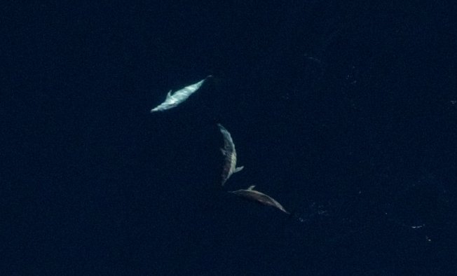
Common dolphin photographed by contractors for the New York State Energy Research & Development Authority is conducting aerial photo surveys of marine life in the ocean south of Long Island where wind farm development is expected to boom in the next two decades. Normandeau Associates/APEM Ltd. Environmental Imaging Solutions
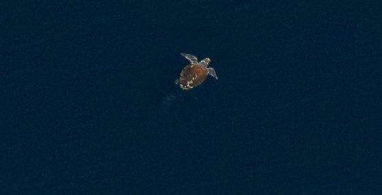
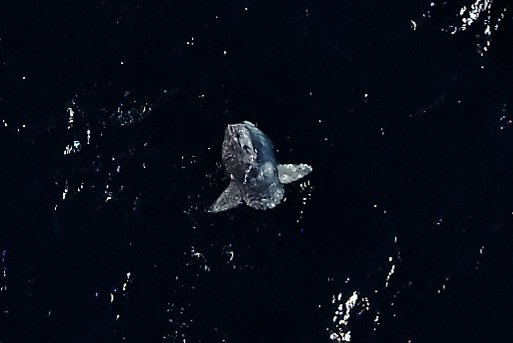
A loggerhead sea turtle photographed by surveyors for the New York State Energy Research & Development Authority
which is conducting aerial photo surveys of marine life in the ocean south of Long Island where wind farm development is expected to boom in the next two decades. Normandeau Associates/APEM Ltd. Environm
Taking count of wildlife in the vast expanses of the ocean is a notoriously difficult and inexact science, since many of the species sought are underwater and not readily visible the way animals on land are.
In preparing for what is expected to be a rush of development of wind farms in the Atlantic Ocean to the south of Long Island in the coming years, New York State is attempting to bolster documentation of what animals—especially endangered or particularly sensitive ones—are using what areas of the sea, so that they may tailor wind farm development to accommodate and protect wildlife.
For the last three years, an environmental consulting firm has been flying a small twin-prop plane outfitted with ultra-high-resolution cameras across some 16,000 square miles of ocean, from Montauk to the New Jersey coastline, taking hundreds of thousands of photos as it goes back and forth, back and forth, back and forth.
The cameras—which produce images that can detail an object the size of a nickel—have captured giant fin, humpback and sperm whales, pods of frolicking common dolphin, sharks chasing schools of smaller fish, packs of the brilliant green fish known as mahi mahi lingering under floating debris, pelagic oddities like the ocean sunfish and hundreds of species of birds as they make their way through one of the most active regions of the Atlantic for both animals and humans.
The passage of animals through the New York Bight has been tracked for centuries, of course, but from a scientific statistician’s standpoint it has not been kept up to date, which, with a lot of factors about to change, is now the mission of the New York State Energy Research and Development Authority.
“The intent is to bring contemporary data to the ocean study area,” said Greg Lampman, the environmental research program manager for NYSERDA, who is overseeing the surveys being conducted by Normandeau Associates. “Some of the current data is 20 to 40 years old. Having a comprehensive understanding of wildlife will help us decide where we can site projects that will have the least impact on wildlife. And it will help developers understand which wildlife we really need to pay attention to in permitting projects.”
As wind farm development has stormed onto the scene in the Northeast, concerns have intensified about some highly endangered species, including perhaps most significantly the few hundred remaining northern right whales, which swim each year through seas that seem destined to be also be home to hundreds of wind turbines in the next decade.
Aerial surveys have been used for years by groups seeking to take measure of how many and what species of animals are swimming through the New York Bight, which can be used to extrapolate broader estimates of the numbers of a given species using an area. The State Department of Environmental Conservation conducts aerial surveys every year, but using simple human observation from planes rather than photos. The difference in the two studies is a matter of scope and in reproduction.
Planes carrying human observers must fly just a few hundred feet above the ocean to allow observers the chance to see individual animals with the naked eye and identify their species. The Normandeau planes fly at 1,350 feet, which substantially increases the breadth of coverage in the images captured, while the high-resolution photos can be scanned by a computer to pick up on individual animals that can be zoomed in on for scientific identification and precise location.
That extra height is also significant for the future applicability of the surveys. Planes will be able to continue flying the same survey transects even when dozens of offshore wind turbines, which could tower more than 800 feet above the sea surface, are scattered throughout the survey area, allowing for long-term tracking of the impacts of wind farms on animal migrations.
“So we can replicate this survey after construction and see how distribution has changed,” Mr. Lampman said. “Developers do surveys of their project, but that doesn’t always explain how wildlife moves around their site. It’s an easy technology for developers to pick up and use to build on the existing data set.”
And the digital nature of the information, he added, should make it possible for researchers to make note of any impacts seen once the first wind farms are built and take them into consideration in the planning of subsequent development projects.
The current survey is due to wrap up after the flight surveys this spring. The planes have flown 52 transects of the study area four times each year since 2016, snapping photos of about 7 percent of the ocean’s surface in the area. The fall surveys lingered well into last month because of stormy weather and the winter surveys—large whales and sharks and many bird species are still transiting the waters off Long Island in the depths of winter—will begin again in February.
“The challenge is finding time when flying is safe,” Mr. Lampman said. “And we also need to have conditions without a glare on the water, which makes it hard to identify organisms.”


 Michael Wright on Dec 31, 2018