


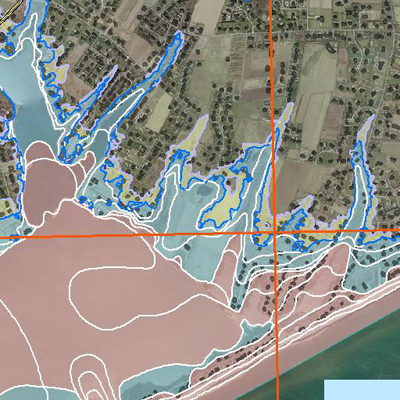
Many areas on the South Fork have been removed from designated flood plain areas on revised maps drafted by the Federal Emergency Management Agency (FEMA), but Sagaponack Village actually has seen more houses included among those at risk in the event of a flood, a change that could impact insurance policies for some homeowners.
According to the new FEMA flood maps, which were released last year, there are 73 more homes in the flood plains in Sagaponack than there were on the old maps, which date back to 1983.
But the good news is that the current homeowner insurance for those 73 houses, and any others throughout Southampton Town in similar circumstances, should not be affected, according to Chris McDonald, a principal at Amaden Gay Agency in East Hampton. The bad news is that those seeking new policies most likely will be affected.
“The homeowners insurance company isn’t going to know if the flood zone is changed,” Mr. McDonald said. “They’re not going to check.”
But if those who are now in the flood plains look to change their policy or refinance their home, they could run into trouble, Mr. McDonald said. In both those cases, either the insurance institution or bank would investigate the flood zone on the home and could reject applications for insurance policies or a refinancing plan, he explained.
Still, some homeowners can find a way around this. If homeowners who were not initially in the flood plains but will be once the maps become effective buy insurance for their houses before September 25, they can obtain insurance at a lower rate, explained FEMA spokeswoman Barbara Lynch. Those who buy flood insurance for their homes before September 25 will receive the same protection as they would if they were purchasing insurance at a higher rate, Ms. Lynch said.
“They’re grandfathered in,” Ms. Lynch said.
Before the publication of the new maps, 46 homes in Sagaponack were designated as being in the flood plain. Now there are 119 in the area of high risk, according to FEMA documents. All municipalities affected by the new FEMA maps have to adopt the maps and issue a local law outlining the new flood plains by September 25 or risk jeopardizing the flood insurance of their constituents, said Rich Einhorn, a FEMA spokesman.
So far, Westhampton Beach has adopted the laws, according to Aram Terchunian, a coastal geologist with an office in Westhampton Beach. Sagaponack Mayor Don Louchheim noted that his village will have a public hearing on the laws in September.
West Hampton Dunes and Southampton Town will be adopting the laws within the next few weeks and Sag Harbor leaders have also been considering the new laws, according to Mr. Terchunian. Most areas are adopting the new flood map areas without much debate, he said.
Mr. McDonald said that those seeking flood insurance will not find it more difficult to obtain coverage if they are now in an area at high risk for flooding—they will just have to pay a different rate for flood insurance, he explained.
“People can get flood insurance, but in most cases it will be more expensive,” Mr. McDonald said.
He noted that primary flood insurance, which is provided by the federal government, covers up to $250,000 per house. In areas like Sagaponack, where homes are worth considerably more than that, homeowners can look for a secondary insurance policy.
“Those people have to find other homeowner’s insurance, and then they get put in assigned risk,” said Mr. Terchunian, adding that assigned risk—a category of insurance that means homes are more prone to damage—is usually more expensive.
Mary Colvin, the manager for the Long Island FEMA branch, said one reason FEMA considers more homes in Sagaponack to be at a higher risk for flooding is because of new technology the agency uses to map the shoreline.
“Essentially how it works is that an airplane flies over the area, shoots laser beams at the ground and then they bounce back to create a detailed topographic map,” Ms. Colvin said. “It allows us to provide a better topography.”
But technological advances are not the only reason more homes in Sagaponack are considered at risk for flooding, according Mr. Terchunian. He explained that the groins lining the coast in East Hampton have caused massive beach erosion in Sagaponack, weakening the dunes, which are the main protection against storm surges and large waves.
In fact, Southampton Town and Cynthia Ireland, a Sagaponack homeowner, filed a joint lawsuit more than 10 years ago against Suffolk County over the placement of the groins because they proved so destructive in the Sagaponack and Bridgehampton area. There has been ongoing litigation over the lawsuit in Suffolk County Supreme Court.
Mr. Terchunian added that bodies of water in the village, such as Sagaponack Pond and Fairfield Pond, also increase the potential for dangerous floods. In a major storm, the waves could break over the dunes into the ponds and cause a breech in the dunes. A similar situation occurred in West Hampton Dunes during a nor’easter in the early 1990s, when a wave broke into Moriches Bay through a narrow strip of Dune Road.
“The houses around the ponds are more susceptible to flooding because of breaching,” Mr. Terchunian said, adding that all of the homes around ponds are now at risk of being swallowed in a flood.


 Joseph Shaw, Executive Editor on Aug 25, 2009